After a mix of rain, snow, and ice impacted the Northeast at the start of the week, AccuWeather meteorologists are tracking the development of a stronger storm expected to reach the region by Tuesday night.
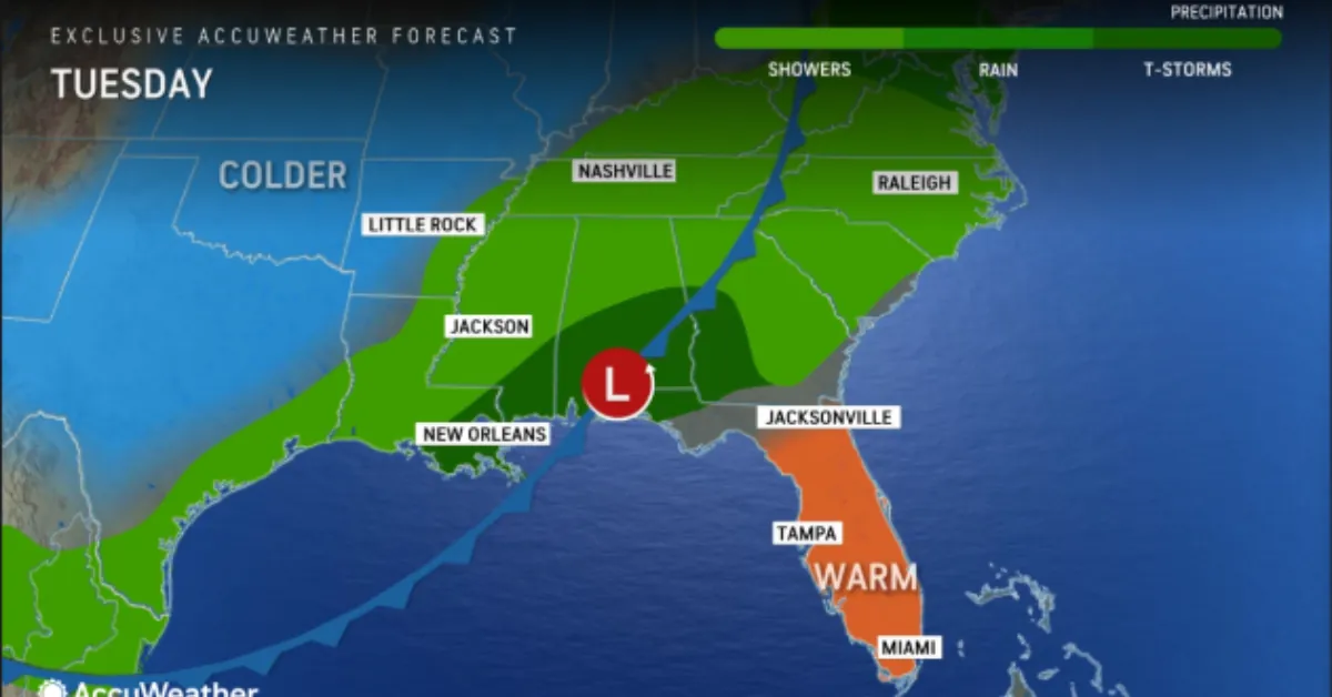
The storm is anticipated to gather strength in the Southeast by Tuesday, where warm, moist air will fuel thunderstorms in areas such as southeastern Louisiana, southeastern Mississippi, central and southern Alabama, and southwestern Georgia.
While the overall severe weather risk is low, the combination of adequate moisture and strong upper-level winds could lead to gusty winds in any intense downpours.
The storm will intensify as it moves northward along a cold front on Tuesday evening and into Tuesday night. Ahead of the front, mild air will surge northward, minimizing wintry precipitation across the region.
Most areas in the Northeast, with the exception of Maine and parts of Canada, will likely see liquid precipitation by Tuesday night. Heavy rain, fog, and temperatures remaining above freezing could quickly melt existing snow, leading to localized flooding risks.
AccuWeather Meteorologist Grady Gilman noted, “After a cold, snowy start to December, areas with deep snowpack—especially those downwind of Lake Erie and Lake Ontario—face an increased risk of flooding.” He further explained that Gulf moisture will surge ahead of a low-pressure system, driving heavy rain through the lower Mississippi Valley, mid-Atlantic, and Northeast over the course of the week.
Senior Meteorologist Bill Deger pointed out that the heaviest rainfall will target the I-95 corridor, from northern Florida to Maine, especially on Wednesday. He cautioned that both morning and evening commutes in cities like Washington, Baltimore, Philadelphia, New York, and Boston could be hindered by downpours, increasing the risk of localized flooding.
Although significant snow amounts are unlikely, colder air arriving on the storm’s backside could transition rain to snow in the interior Northeast and mountainous regions. These rapid temperature drops could also lead to icy road conditions. Gilman added, “Arctic air will move quickly behind the storm, bringing a risk of rapid freezing across the northern mid-Atlantic and Northeast.”
Gusty winds are expected to increase Wednesday afternoon into Thursday as the storm strengthens, both ahead of and behind it. These winds, combined with heavy rain, may lead to flight delays at airports.
Following the initial rain, colder air will trigger lake-effect snow in parts of the Northeast, although snowfall totals are expected to be lower than earlier this month. Some areas, however, may experience increased snow by week’s end, especially where snow melted due to preceding warm temperatures. This could create hazardous travel conditions due to heavy snow and strong winds.
The cold temperatures are expected to subside by the weekend, with conditions warming to near or above historical averages by the start of next week.


![Tyson Foods Plant [Photo: Food Manufacturing]](https://southarkansassun.com/wp-content/uploads/2023/08/iStock_1185520857__1_.5e441daa51cca-600x337.jpg)


![Silverado Senior Living Management Inc. [Photo: Los Angeles Times]](https://southarkansassun.com/wp-content/uploads/2023/10/download-6-4-600x337.jpg)

![China's Wuhan Institute of Virology [Photo: Nature]](https://southarkansassun.com/wp-content/uploads/2023/09/d41586-021-01529-3_19239608-600x337.jpg)


