Arctic Blast Eases Into Warmup, But Snow and Ice Lurk Along the Way
A wave of Arctic air is currently sweeping through the region, but AccuWeather meteorologists warn that the road to milder temperatures will not be smooth. Several storms will cause disruptions, bringing snow and ice in some areas before the warmth arrives.
After a cold start to the weekend, temperatures will gradually rise early next week. In the East, New York City will see temperatures climb into the 40s, while Washington, D.C. will rise from the lower 40s on Saturday to the mid-50s on Sunday.
Chicago will also warm up, with highs reaching near 50°F by Sunday, up from highs in the 30s on Saturday. In the South, temperatures will bounce back into the 50s in Nashville, and Atlanta could see 60°F by Sunday.
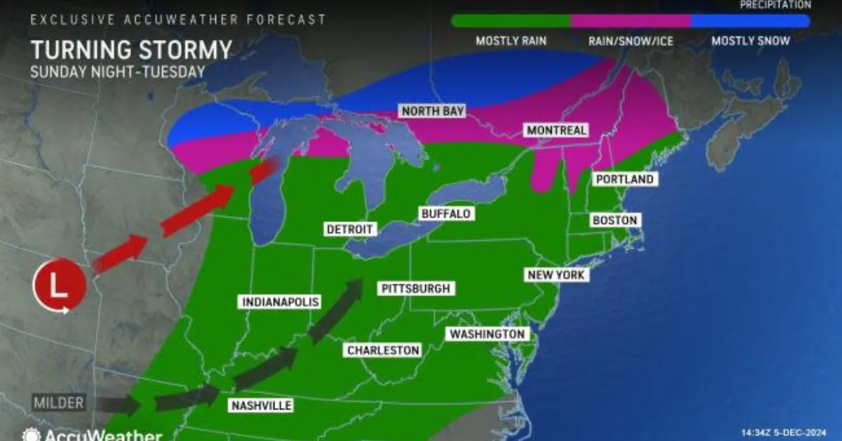
However, the shift to milder weather will be interrupted by a clipper-style storm. The fast-moving storm will travel southeast from central Canada into southern Ontario on Saturday, then into northern New England on Sunday.
Meteorologist Grady Gilman explained that the storm will bring 1 to 3 inches of snow to areas from northwest Ontario to northern New York and northern New England, with local totals of 3 to 6 inches over higher elevations.
To the south of the snow, parts of northern Michigan, southern New York, and central New England will experience rain, sleet, and freezing rain.
Meanwhile, warmer air will gradually move into central and northern New England by the end of the weekend and into early next week. Boston, for example, will see highs well into the 40s on Monday.
The following storm will approach from the southern Plains and the Gulf of Mexico, bringing rain to areas in front of the storm due to milder temperatures.
However, the northern tier of the Northeast could see a mix of snow, ice, and rain, particularly as lingering cold air interacts with the storm. This combination of rain, snow, and fog may create hazardous travel conditions.
Although the rain won’t be heavy enough to cause widespread flooding, it could lead to localized flooding where snow piles block storm drains. Additionally, the weight of the rain on snow-covered roofs could strain structures, potentially leading to damage.
As the warm air continues to push northward, a new cold front will advance southward across the Central states, setting up a storm track from the Appalachians to the Atlantic coast.
Meteorologist Paul Pastelok notes that depending on the storm’s track and intensity, the region could see accumulating snow from the Appalachians to parts of the Tennessee Valley and the Midwest by midweek.


![Tyson Foods Plant [Photo: Food Manufacturing]](https://southarkansassun.com/wp-content/uploads/2023/08/iStock_1185520857__1_.5e441daa51cca-600x337.jpg)


![Silverado Senior Living Management Inc. [Photo: Los Angeles Times]](https://southarkansassun.com/wp-content/uploads/2023/10/download-6-4-600x337.jpg)

![China's Wuhan Institute of Virology [Photo: Nature]](https://southarkansassun.com/wp-content/uploads/2023/09/d41586-021-01529-3_19239608-600x337.jpg)


