A wintry mix of snow and rain is forecasted to move into Massachusetts on Wednesday night, leading to slippery travel conditions on Thursday morning.
In different parts of Massachusetts, the required winter tools can vary. Some areas may require a snow brush, others a snow shovel, while some may not need any tools at all.
The National Weather Service has issued a winter weather advisory for a significant portion of central and western Massachusetts. The advisory is in effect from 8 p.m. on Wednesday to 10 a.m. on Thursday, during which the area is expected to experience the heaviest snowfall.
STORM TIMELINE
Clouds are expected to increase during the day on Wednesday, with the possibility of flurries occurring in inland areas. Additionally, a few spot showers may develop around 4 or 5 p.m. However, the main event is anticipated to occur around 10 p.m.
Overnight into Thursday morning, the heaviest snow and rain will occur, resulting in a damp commute to school and work.
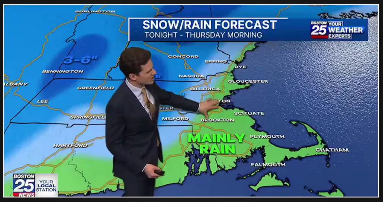
According to the latest forecast from Boston 25 Meteorologist Shiri Spear, the snowfall will reach its peak overnight and early Thursday morning. This means that commuters might have to deal with snowy and wet conditions, depending on their location.
Thursday afternoon could see the potential for snow squalls, those intense bursts of heavy snowfall that come with strong winds and limited visibility.
Thursday night into Friday will bring dry weather and intensifying winds, with gusts of 30-40 mph expected.
Snow and Rain Forecast
The weather forecast indicates that there will be a mix of snow and rain in the coming days.
Conditions in Massachusetts will vary.
North and west of Route 128/Interstate 95 can expect a coating of up to 3 inches of snow. Meanwhile, areas north and west of Interstate 495 should anticipate one to three inches of snowfall.
Some areas at higher elevations, particularly northwest of Worcester, could receive significant snowfall totals ranging from 3 to 5 inches. In northwestern Massachusetts, there is even a possibility of seeing 3 to 6 inches of snow.
Snow and rain are expected in communities closer to the coast. However, it will be challenging for the snow to stick as temperatures are predicted to stay above freezing.
Snow could potentially blanket the grassy areas east of 128 and extend into Boston. However, the roads within the city and across southeastern Massachusetts are expected to mainly be wet due to rain.
Road Conditions
Motorists heading north and west of I-495 should anticipate snowy road conditions on Thursday morning.
Expect slushy or wet conditions on the roads along I-95 west to I-495.
Rain will make the roads on the I-95 corridor east to the coast wet.
Cold Sets In After the Storm
The frigid temperatures return after the storm.
According to Spear, Friday is expected to be cold and windy, with a wind chill of 22, making it the day with the highest wind chill.
The weekend forecast calls for dry conditions with partly cloudy skies.
According to the weather forecast, we can expect rain showers early next week.


![Tyson Foods Plant [Photo: Food Manufacturing]](https://southarkansassun.com/wp-content/uploads/2023/08/iStock_1185520857__1_.5e441daa51cca-600x337.jpg)




![Silverado Senior Living Management Inc. [Photo: Los Angeles Times]](https://southarkansassun.com/wp-content/uploads/2023/10/download-6-4-600x337.jpg)

![China's Wuhan Institute of Virology [Photo: Nature]](https://southarkansassun.com/wp-content/uploads/2023/09/d41586-021-01529-3_19239608-600x337.jpg)


