Country Herald is a community news platform for Kankakee, Iroquois, and Will County. Covering breaking local news, sports, lifestyle and events.
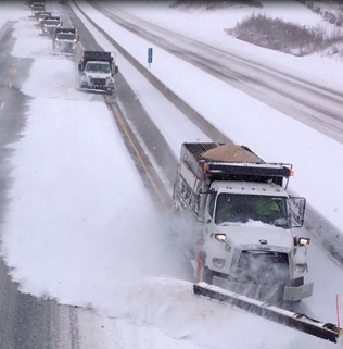
Albuquerque, NM – Winter is returning to New Mexico this week with snow, freezing fog, and plummeting temperatures expected to impact travel along I-25 and I-40 starting Tuesday.
According to the National Weather Service, a cold front will sweep through the state early Tuesday, bringing light to moderate snowfall to the northern and central regions. Accumulations of 2-6 inches are likely in lower elevations, with up to a half-foot possible in mountain areas. Temperatures will drop into the teens and 20s statewide, while wind gusts near 45 mph could create dangerous wind chills.
Snow and freezing fog are expected to develop Tuesday morning in northern areas before expanding southward into Albuquerque and Santa Fe by the afternoon. The most hazardous travel conditions will likely occur during the Tuesday evening commute, particularly along stretches of I-25 near Raton Pass and I-40 through Clines Corners.
Drivers are urged to plan ahead, slow down, and allow extra travel time. Freezing fog will reduce visibility, while icy patches will make roads slick. Residents should also take precautions to protect pets, plants, and pipes as subfreezing temperatures are expected to persist through Friday.
The storm system is forecast to weaken by late Thursday, with slightly warmer temperatures arriving by the weekend. However, nighttime lows will remain in the single digits in some areas. Officials recommend monitoring weather updates and staying prepared for potential Winter Weather Advisories.
Be sure to follow us on Instagram & like us on Facebook to stay up-to-date on more relevant news stories and SUPPORT LOCAL INDEPENDENT NEWS!
The post New Mexico Prepares for Freezing Fog, Snow Along I-25 and I-40 This Week appeared first on Country Herald.




![Tyson Foods Plant [Photo: Food Manufacturing]](https://southarkansassun.com/wp-content/uploads/2023/08/iStock_1185520857__1_.5e441daa51cca-600x337.jpg)





![Silverado Senior Living Management Inc. [Photo: Los Angeles Times]](https://southarkansassun.com/wp-content/uploads/2023/10/download-6-4-600x337.jpg)

![China's Wuhan Institute of Virology [Photo: Nature]](https://southarkansassun.com/wp-content/uploads/2023/09/d41586-021-01529-3_19239608-600x337.jpg)


