Country Herald is a community news platform for Kankakee, Iroquois, and Will County. Covering breaking local news, sports, lifestyle and events.
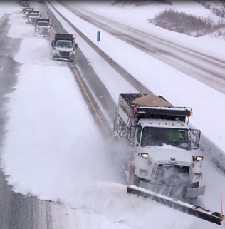
Van Buren County, IA – A significant winter storm is sweeping through Iowa, bringing heavy snowfall and dangerous road conditions. Drivers are urged to delay non-essential travel as blowing snow threatens to reduce visibility Monday morning.
According to the National Weather Service, Van Buren County remains under a Winter Storm Warning until 6 a.m. Monday. Snow accumulations of 3 to 5 inches are expected, with icy bridges and overpasses creating hazardous conditions. Gusting winds will worsen visibility, particularly on rural and west-east roads.
Residents planning to travel should pack a flashlight, food, and water in their vehicles. Officials advise allowing extra travel time, avoiding sudden braking, and maintaining significant distance from other vehicles. Updated road conditions are available at IA511.org or by calling 511.
As snow tapers off Monday, temperatures will remain in the mid-20s, leading to persistent icy spots. Tuesday is forecasted to be drier with a high near 30°F, but another system could bring additional snow by Thursday.
The winter storm poses a significant risk for Monday’s commute, especially for those traveling early. Keep an eye on updated weather alerts and prepare for sudden changes in conditions. Make sure vehicles are winterized and equipped for emergencies.
Stay safe this week by monitoring the weather and heeding local advisories. Plan ahead to avoid unnecessary risks during this winter storm.
Be sure to follow us on Instagram & like us on Facebook to stay up-to-date on more relevant news stories and SUPPORT LOCAL INDEPENDENT NEWS!
The post Heavy Snowfall to Impact Monday Commute: 8 Inches Expected Along Iowa-Illinois Border appeared first on Country Herald.


![Tyson Foods Plant [Photo: Food Manufacturing]](https://southarkansassun.com/wp-content/uploads/2023/08/iStock_1185520857__1_.5e441daa51cca-600x337.jpg)


![Silverado Senior Living Management Inc. [Photo: Los Angeles Times]](https://southarkansassun.com/wp-content/uploads/2023/10/download-6-4-600x337.jpg)

![China's Wuhan Institute of Virology [Photo: Nature]](https://southarkansassun.com/wp-content/uploads/2023/09/d41586-021-01529-3_19239608-600x337.jpg)


