A massive winter storm system is set to sweep across the country in the coming days, but its exact path and the amount of snow it will bring to New Jersey remains uncertain.
Residents can expect the system to reach the state late Sunday night or early Monday morning, potentially leading to significant snow accumulation.
Weather forecasters are uncertain about the storm’s impacts on our region due to the lack of consensus among computer models.
There is still a high degree of uncertainty regarding whether the storm will move south of New Jersey or come closer to our area.
Forecasters said on Friday that if the majority of the storm coming from the Central Plains moves further south, it would result in lesser snowfall in North Jersey.
Instead, South Jersey would experience only light or moderate snow accumulations from late Sunday night through Monday evening.
If the storm track moves further north and closer to the Garden State, it will result in higher snow accumulation for our area.
According to the National Weather Service’s Mount Holly office, there is a possibility of snowfall accumulations across the entire forecast area.
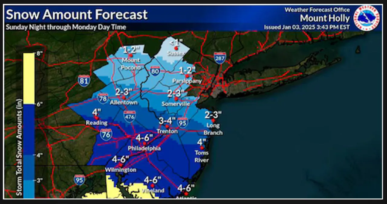
The highest amounts of snow are expected near and/or south of the Philadelphia metro area into Delmarva and southern NJ.
Moderate to heavy snow is expected in the southern half of New Jersey from late Sunday night through much of the day on Monday, according to weather forecasters.
This could result in dangerous road conditions. The National Weather Service has issued this warning.
According to the weather service, there is a considerable amount of uncertainty in the snow forecast.
However, they are expecting a snowfall event of around 4 to 6 inches for areas located between I-76 and I-195, including the Philadelphia metro.
It is worth noting that within this area, there is a chance of heavy snow bands in certain isolated locations, which could result in accumulations of 6 to 8 inches.
If the snow mixes with sleet or rain, it could reduce the numbers mentioned earlier.
The weather service predicts that areas between Interstate 80 and the Interstate 76/Interstate 195 corridor will receive snowfall ranging from 2 to 4 inches. However, areas north of I-80 are expected to receive less than 2 inches of snow.
The weather service mentioned that the snowfall will vary across the region, with a notable difference in the north due to the convergence of dry air. They also acknowledged that some of the predicted snowfall totals might be slightly overestimated.
According to the New York regional office of the weather service, there is a possibility of a light snowfall in New York City and northeastern counties in New Jersey on Monday. The snowfall is expected to range from a coating to 2 inches.
According to forecasters, slight variations in the track of the storm could result in either an increase or decrease in the amount of snowfall by a few inches.
According to the weather service, snowfall is predicted to start in eastern Pennsylvania and western New Jersey on Sunday night. It will continue throughout Monday morning and afternoon, gradually tapering off as light snow or flurries by Monday night.
According to the National Weather Service, there is a chance of moderate to heavy snowfall in the southern half of New Jersey starting late Sunday night and continuing throughout the day on Monday. This could potentially result in hazardous road conditions.
Drivers will face challenging travel conditions on Sunday night through Monday if heavy snowfall occurs, as roads will be covered in snow, according to the weather service.
According to AccuWeather forecasters, South Jersey is expected to receive 3 to 6 inches of snow accumulations, while Central Jersey may see 1 to 3 inches of snow. However, far northern sections of New Jersey are not expected to experience any significant snow accumulation.
Officials in Atlantic City are hoping for light snow but preparing for heavy snow, according to Scott Evans, the city’s fire chief and emergency management coordinator.
He expressed concerns about the potential trouble caused by the upcoming snowfall. Evans stated, “Once we get above two inches, we have to get the plows out. We’re preparing for the worst-case scenario if we get eight inches.
But we’re hoping for the best scenario, which would be just a couple of inches.” This proactive approach highlights the city’s readiness to tackle the challenges posed by the anticipated snowstorm.
AccuWeather forecasters are predicting snow accumulations of 3 to 6 inches in South Jersey, 1 to 3 inches in Central Jersey, and virtually no accumulating snow in far northern sections of New Jersey from late Sunday night, Jan. 5, through Monday evening, Jan. 6, 2025. (AccuWeather)
Smaller storm on Friday
Parts of South Jersey are currently experiencing a light coating of snow as a smaller storm system made its way from the west on Friday afternoon.
A winter weather advisory is currently in effect until 10 p.m. Friday in Atlantic, Camden, Cape May, Cumberland, Gloucester, and Salem counties due to the potential for slippery roads caused by snow.
The weather service has issued a warning, stating that roads, particularly bridges and overpasses, may become slippery and dangerous. They advise drivers to exercise caution and reduce their speed while traveling.
New winter weather advisories or winter storm watches may be issued in New Jersey this weekend, depending on the development of the next storm system.
Current weather radar
We deeply appreciate your trust in us to deliver reliable local weather news. If you find value in our content, we kindly request you to consider supporting NJ.com through a voluntary subscription.


![Tyson Foods Plant [Photo: Food Manufacturing]](https://southarkansassun.com/wp-content/uploads/2023/08/iStock_1185520857__1_.5e441daa51cca-600x337.jpg)




![Silverado Senior Living Management Inc. [Photo: Los Angeles Times]](https://southarkansassun.com/wp-content/uploads/2023/10/download-6-4-600x337.jpg)

![China's Wuhan Institute of Virology [Photo: Nature]](https://southarkansassun.com/wp-content/uploads/2023/09/d41586-021-01529-3_19239608-600x337.jpg)


