The forecast for severe weather in East Texas has been upgraded by the Storm Prediction Center. The atmospheric conditions are rapidly changing, increasing the potential for widespread severe weather in east and southeast Texas today (12/26).
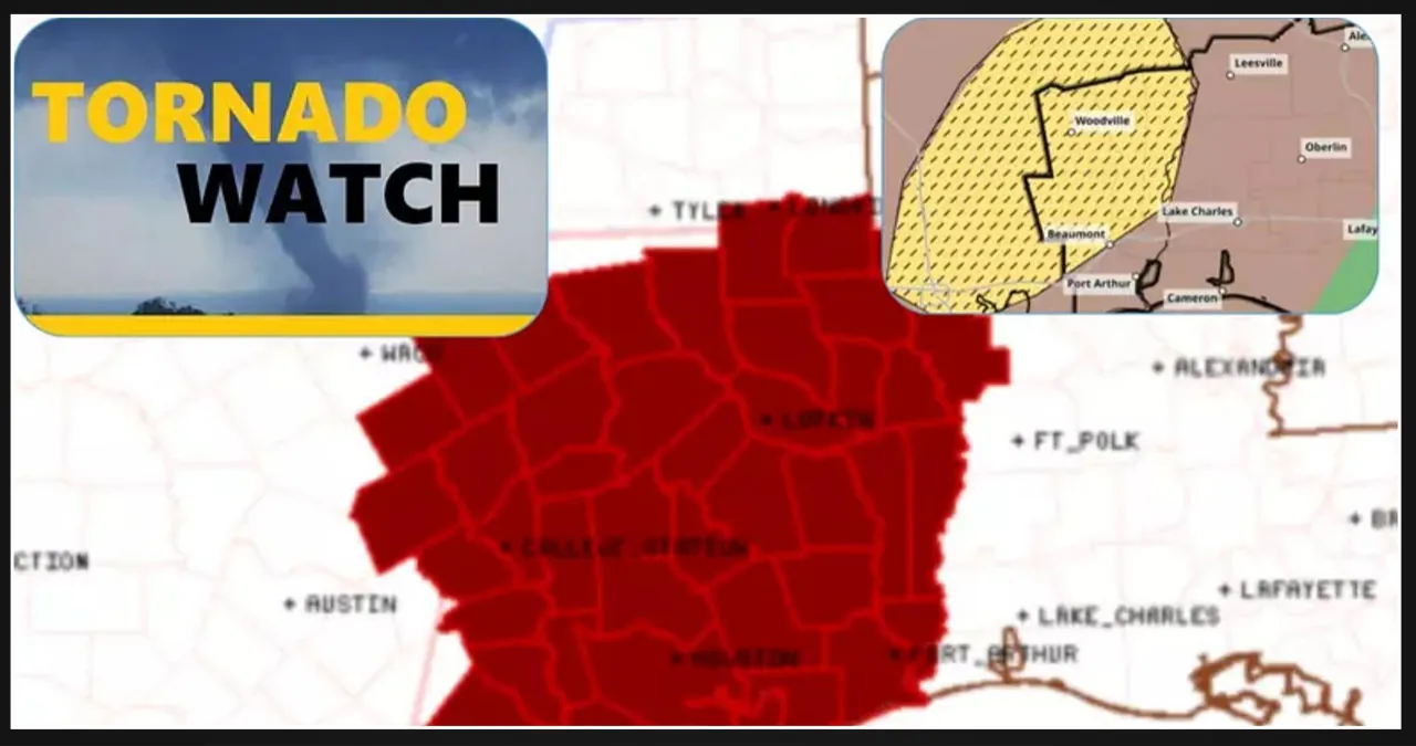
The shaded brown area highlights the region where severe storms are most likely to occur today and into the evening.
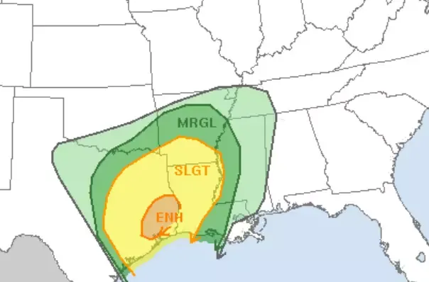
The Storm Prediction Center, a division of the National Weather Service, has released a new forecast that predicts severe storms in the coming days. The forecast includes the risk of tornadoes, damaging winds, and large hail in several states across the country.
According to the report, the storms are expected to develop in the afternoon and evening hours, with the greatest threat occurring during the late afternoon and evening.
Residents in the affected areas are advised to stay alert and take necessary precautions to ensure their safety.

Regrettably, the aforementioned region also holds an increased threat of powerful tornadoes, specifically those classified as EF2 to EF5. This is highlighted in the hatched area showcased in the following map.
The Storm Prediction Center, a division of the National Weather Service, is responsible for monitoring and forecasting severe weather conditions in the United States. They use advanced technology and data analysis to assess the potential for severe thunderstorms, tornadoes, and other hazardous weather events.
By analyzing atmospheric conditions, historical patterns, and real-time observations, the Storm Prediction Center can issue alerts and warnings to help keep the public safe. Their expertise and timely information play a crucial role in minimizing the impact of severe weather on communities across the country.
When you examine the two maps provided below, you will observe that the expanded area encompasses cities such as Houston, Pearland, Livingston, Jasper, Woodville, San Augustine, and Lufkin.
The Lake Charles National Weather Service (NWS) provides weather forecasts and alerts for the Lake Charles area.
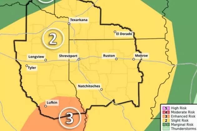
The Shreveport National Weather Service (NWS) is an important resource for weather information in the area. They provide forecasts, warnings, and other valuable data to help keep the community informed and safe.
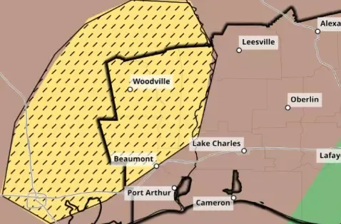
The NWS uses advanced technology and meteorological expertise to analyze and predict weather patterns, ensuring accurate and timely information. Their dedication to public safety is evident in their commitment to providing up-to-date forecasts and severe weather alerts.
By relying on the Shreveport NWS, residents and visitors can stay informed and make informed decisions to protect themselves and their property from the impacts of severe weather events.
Tornadoes with winds exceeding 111 mph are classified as EF2 twisters, while EF3 tornadoes start at 136 mph. You can view the complete Fujita scale here.
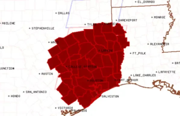
The watch covers Angelina, Nacogdoches, and the entire Deep East Texas region, as well as the Greater Houston Metro.
The watch goes into effect right away and remains in place until 7 PM this evening. The main risks associated with this watch are the likelihood of a few tornadoes, with the potential for a couple of intense tornadoes.
There is also the possibility of scattered large hail, with isolated events of very large hail up to 2 inches in diameter. In addition, there is a chance of scattered damaging wind gusts reaching up to 70 mph.
Scattered supercell development is anticipated in southeast Texas during the afternoon and evening, with storms forecasted to move northeastward into east-central Texas. The storm environment has the potential to produce multiple tornadoes, including a few strong (EF2+) tornadoes.
Additionally, there is a risk of large hail measuring 1-2 inches in diameter and isolated severe outflow gusts reaching 60-70 mph.
Ensure that you have made all the necessary arrangements and taken proper precautions in the event of a tornado approaching your location or home.
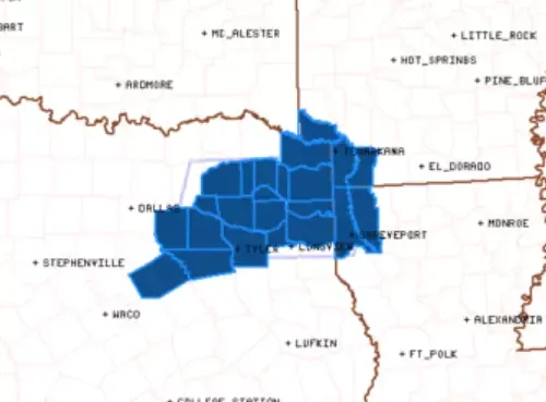
Severe Thunderstorm Watch
A severe thunderstorm watch is currently in effect until 7 p.m. this evening for Tyler, Longview, and the surrounding counties in northeast Texas and the Ark-La-Tex area.


![Tyson Foods Plant [Photo: Food Manufacturing]](https://southarkansassun.com/wp-content/uploads/2023/08/iStock_1185520857__1_.5e441daa51cca-600x337.jpg)




![Silverado Senior Living Management Inc. [Photo: Los Angeles Times]](https://southarkansassun.com/wp-content/uploads/2023/10/download-6-4-600x337.jpg)

![China's Wuhan Institute of Virology [Photo: Nature]](https://southarkansassun.com/wp-content/uploads/2023/09/d41586-021-01529-3_19239608-600x337.jpg)


