An Arctic cold front is expected to cause hazardous travel conditions across the Great Lakes and northeastern United States from Wednesday, December 4, to Thursday, December 5, 2024.
The cold front will bring strong winds, heavy snow squalls, and whiteout conditions as it sweeps across the region. These conditions will significantly impact the Great Lakes, Ohio Valley, Central Appalachians, and parts of the Northeast.
As the front moves east, snow squalls are anticipated, with brief but intense bursts of heavy snowfall, creating dangerous travel conditions.
These squalls, along with gusty winds, will cause whiteout conditions and rapidly deteriorating road conditions, especially in the Great Lakes and Northeast regions.
Travel across these areas will be particularly hazardous, with icy roads and low visibility complicating commutes.
Winds are expected to reach up to 80 km/h (50 mph), extending from the Northern Plains to the Great Lakes and continuing towards the Central Appalachians, Mid-Atlantic, and Northeast by Thursday.
This could lead to tree damage, power outages, and additional travel issues. Areas downwind of the Great Lakes are likely to experience heavy lake-effect snow, with accumulations of 30–60 cm (1–2 feet) expected in the snow belts.
The Central Appalachians and parts of interior New England may also see significant snow, with up to 30 cm (1 foot) possible in higher elevations.
Blizzard-like conditions are possible in lake-effect snow regions and over parts of the Central Appalachians, further complicating travel.
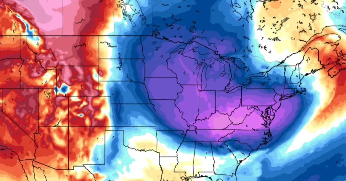
Behind the front, an Arctic air mass will bring sharply colder temperatures, with highs expected to be 11–17 °C (20–30 °F) below average, especially across the Midwest and Central Appalachians on Thursday. Low maximum temperature records are likely to be broken along the lower Ohio River Valley.
By Friday, the Arctic air will extend to the Gulf Coast and East Coast, with temperatures 6–14 °C (10–25 °F) below average in many areas. Meanwhile, the western U.S. will continue to experience above-average temperatures due to a ridge of high pressure.


![Tyson Foods Plant [Photo: Food Manufacturing]](https://southarkansassun.com/wp-content/uploads/2023/08/iStock_1185520857__1_.5e441daa51cca-600x337.jpg)


![Silverado Senior Living Management Inc. [Photo: Los Angeles Times]](https://southarkansassun.com/wp-content/uploads/2023/10/download-6-4-600x337.jpg)

![China's Wuhan Institute of Virology [Photo: Nature]](https://southarkansassun.com/wp-content/uploads/2023/09/d41586-021-01529-3_19239608-600x337.jpg)


