Millions of people across the Upper Midwest to the mid-Atlantic and Northeast are bracing for a new winter storm. This storm brings with it dangerous winds and the potential for blizzard or near-blizzard conditions. These areas have already been hit hard by a lake-effect snowstorm that left cities buried under several feet of snow.
The heavily traveled Interstate 95 corridor may even experience some snowfall during the storm.
A storm system, referred to as an “Alberta clipper” because of its rapid speed and origin within the Canadian province, has already entered the United States. As the day progresses, its effects will intensify across the Great Lakes and Upper Midwest.
Winter weather alerts have been issued across a wide area, spanning from North Dakota to Maine. These alerts include blizzard warnings, which have been issued in parts of West Virginia and Maryland in the mid-Atlantic region.
The warnings have been prompted by the forecast of heavy snowfall and high winds, which are expected to create whiteout conditions. As a result, travel in these areas is expected to be extremely dangerous and could pose a serious threat to life.
Wednesday will once again see the heaviest snowfall primarily due to lake effects, particularly along the eastern shores of Lake Superior and Lake Michigan.
Michigan’s western snow belts and the Upper Peninsula are currently under winter storm warnings, as new snow totals are expected to exceed a foot.
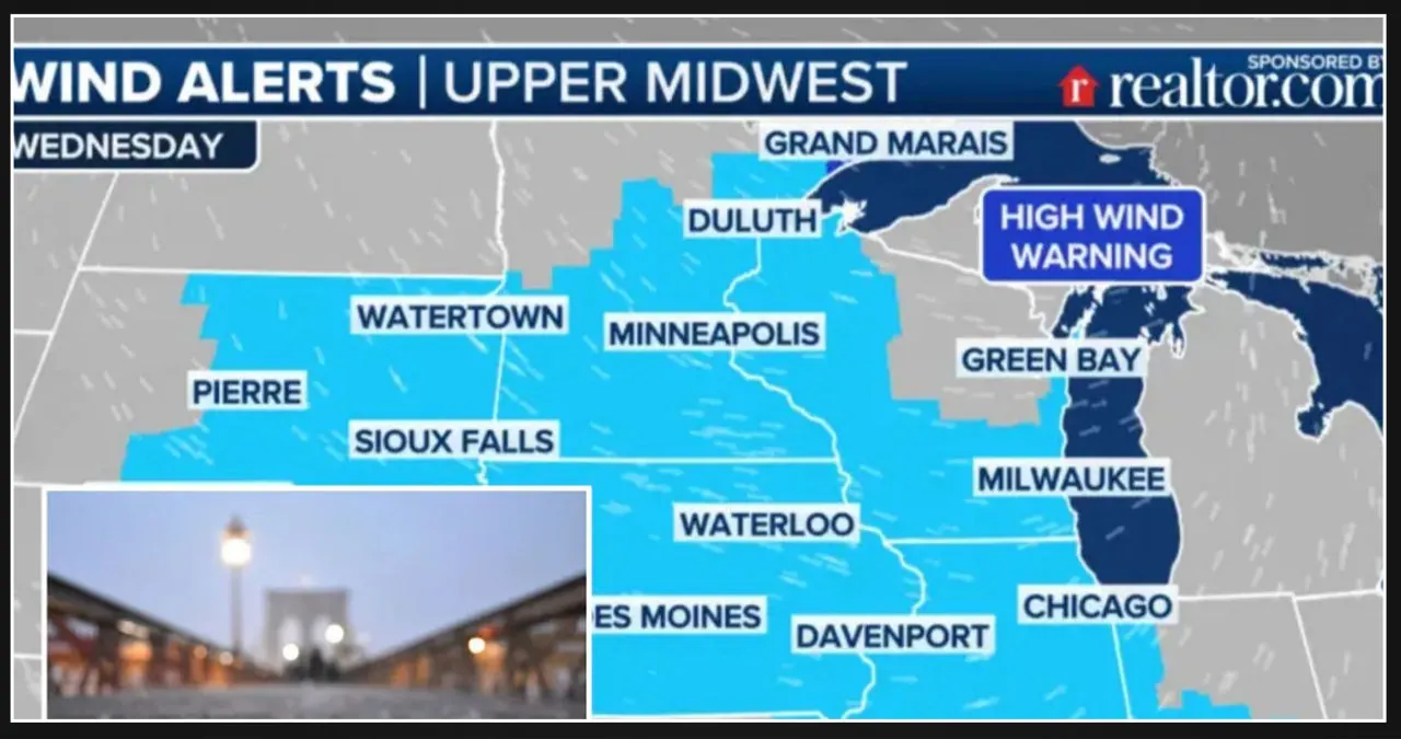
Scattered snow squalls may occur across the Upper Midwest and Great Lakes on Wednesday, accompanied by widespread wind gusts of 40 to 50 mph. These conditions have the potential to create near-blizzard or whiteout conditions.
Storm shifts heavy snow and high winds to the Northeast on Thursday
On Thursday, a clipper system is expected to move across the Northeast, causing heavy snowfall along the eastern shores of Lake Erie and Lake Ontario.
FOX Weather meteorologist Ian Oliver explains that the cold air coming straight down from Canada is the main reason why many people in the eastern part of the country are experiencing below-average temperatures.
This strong wind also contributes to the continuous production of lake-effect snow. In summary, December is starting off with a significant weather event.
Winter storm watches and lake-effect snow warnings are once again in effect from late Wednesday through Thursday night. The eastern shores of Lake Ontario and Lake Erie are expected to receive an additional 7 to 12 inches of snow, with isolated higher amounts possible.
These areas have already been dealing with the aftermath of the 3 to 5 feet of lake-effect snow that has accumulated since Friday.
The storm center is expected to bring heavy snow to interior New England and Maine on Thursday.
Upstate New York and western and northern Pennsylvania are forecasted to receive lighter but accumulating snowfall in the lower elevations.
During the previous lake-effect snowstorm, high winds did not play a significant role. However, this time around, the Northeast will experience fierce winds as the powerful low-pressure system moves across the area.
Expect gusts of wind between 40 and 50 mph, which will result in near-blizzard conditions in the areas experiencing lake-effect snow.
Wind advisories have been issued for over 77 million people across a wide area spanning from the Dakotas to Massachusetts. This includes major cities such as Minneapolis, Chicago, Washington, DC, and New York. These advisories serve as a warning to the population about the potential risks and hazards associated with strong winds.
In the Minneapolis area, winds are expected to reach gusts of up to 50 mph. Similarly, Cape Cod and Nantucket in Massachusetts may experience tropical storm-force wind gusts.
Will it snow along the I-95 corridor?
Some areas along the I-95 corridor could potentially experience wet snow or a mix of rain and snow, depending on the timing of the storm on Thursday.
New York, Philadelphia, and Boston have not experienced any measurable snowfall this season. However, on Tuesday, Central Park did report its first “trace” of snow.
The storm is not anticipated to result in significant snow accumulation for the I-95 corridor. However, the strong winds accompanying the storm could potentially cause sporadic power outages.


![Tyson Foods Plant [Photo: Food Manufacturing]](https://southarkansassun.com/wp-content/uploads/2023/08/iStock_1185520857__1_.5e441daa51cca-600x337.jpg)




![Silverado Senior Living Management Inc. [Photo: Los Angeles Times]](https://southarkansassun.com/wp-content/uploads/2023/10/download-6-4-600x337.jpg)

![China's Wuhan Institute of Virology [Photo: Nature]](https://southarkansassun.com/wp-content/uploads/2023/09/d41586-021-01529-3_19239608-600x337.jpg)


