


![Tyson Foods Plant [Photo: Food Manufacturing]](https://southarkansassun.com/wp-content/uploads/2023/08/iStock_1185520857__1_.5e441daa51cca-600x337.jpg)


![Silverado Senior Living Management Inc. [Photo: Los Angeles Times]](https://southarkansassun.com/wp-content/uploads/2023/10/download-6-4-600x337.jpg)

![China's Wuhan Institute of Virology [Photo: Nature]](https://southarkansassun.com/wp-content/uploads/2023/09/d41586-021-01529-3_19239608-600x337.jpg)


Where Earth Shows Off Its Best Work
Many Arizona landscapes look so alien because the state sits where three major geological zones crash into each other.
The stable Colorado Plateau pushed upward, exposing ancient rocks. Then the Basin and Range area got stretched like taffy, creating parallel mountain ranges. And you also have the Transition Zone between them mixed everything up.
In short, Arizona is loaded with mind-boggling gems, and here are some of our favorites.

1. Grand Canyon
The Colorado River sliced through a mile of rock here, revealing 2 billion years of Earth’s history in one giant cross-section.
The oldest rocks at the bottom—dark Vishnu Schist—formed before plants or animals even existed. Look for the Great Unconformity where a billion years of rock is missing, erased by ancient glaciers.
The canyon walls display 40 distinct rock layers. That reddish Supai Formation? Ancient river mud. The white Coconino Sandstone is a Sahara-like desert from 275 million years ago. Green Bright Angel Shale contains fossils of trilobites and other creatures from when Arizona sat under a tropical sea.
To really get it, hike below the rim. The South Kaibab Trail takes you through multiple rock layers in just a couple miles, like walking backward through time.
- Address: Grand Canyon National Park, AZ 86023
- Fees: $35 per vehicle (7 days); America the Beautiful passes accepted
- Hours: South Rim open 24/7 year-round; North Rim open mid-May to mid-October
- Getting There: 80 miles northwest of Flagstaff via Highway 180

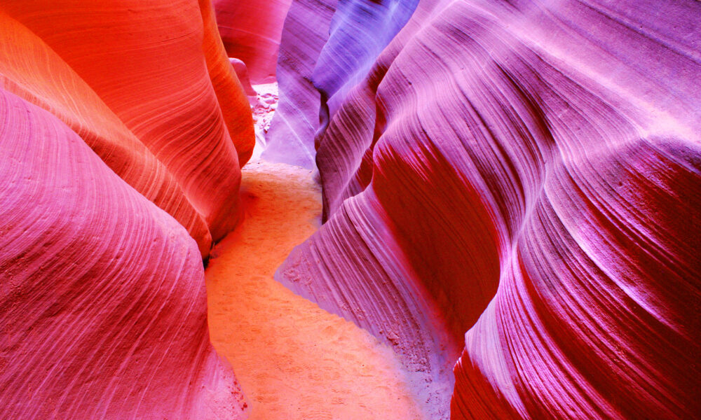
2. Antelope Canyon
These rocks started as sand dunes 190 million years ago and were buried, hardened, then cracked by earth movement. The canyon’s orange-red glow comes from iron oxide in the Navajo Sandstone.
Water is also the sculptor here, not in gentle streams but violent flash floods, carrying sand that sandblasted the walls. This created the smooth, flowing curves that look almost liquid.
Upper Antelope Canyon has the famous light beams but gets crowded. Lower Antelope requires ladder climbing but rewards you with more intricate swirling patterns and fewer people jostling for photos.
- Address: Highway 98, Page, AZ 86040
- Fees: Upper Canyon tours $60-$90; Lower Canyon tours $40-$80 (plus $8 Navajo permit)
- Hours: Tours run daily; best light March-October, 10:30am-1:00pm
- Getting There: 10 minutes east of Page; must join authorized Navajo tour

3. Monument Valley
The formations were once part of a massive plateau, but rain and wind stripped away everything except these resistant sandstone towers.
The most famous formations include the Mittens (twin buttes shaped like hands), Three Sisters, and Elephant Butte. Drive the 17-mile loop for closeup views, but sticking around for sunset is worth it—the low light makes the rocks glow like they’re lit from within.
- Address: Monument Valley Navajo Tribal Park, US-163, Oljato-Monument Valley, UT 84536
- Fees: $20 per vehicle (up to 4 people); guided tours $75-$150
- Hours: May-September: 6am-8pm; October-April: 8am-5pm
- Getting There: 175 miles northeast of Flagstaff via US-160 and US-163

4. Horseshoe Bend
The Colorado River makes a dramatic U-turn here, wrapping around a resistant sandstone ridge in a perfect 270-degree curve. The river began carving this bend about 5 million years ago when the Colorado Plateau started rising.
Stand at the edge of the 1,000-foot drop and you’ll see clear evidence of the river’s power. The overlook has no guardrails except in a small viewing area, so watch your footing.
- Address: Mile Marker 545, US-89, Page, AZ 86040
- Fees: $10 per vehicle
- Hours: Dawn to dusk daily
- Getting There: 5 miles southwest of Page; 0.75-mile hike each way from parking

5. The Wave (Coyote Buttes North)
This surreal landscape looks like ocean waves frozen in stone, though it formed in a bone-dry desert. What you’re actually seeing is 190-million-year-old Navajo Sandstone, originally laid down as Jurassic sand dunes.
The vivid swirls of color come from different minerals in the sandstone. Iron compounds create reds and oranges. Manganese produces purples. The yellow layers contain higher concentrations of limonite.
These colors intensified as groundwater dissolved and redeposited the minerals over millions of years.
Getting a permit is notoriously difficult—only 64 people are allowed per day—but it means you’ll share this otherworldly place with just a handful of others.
- Address: Vermilion Cliffs National Monument, AZ
- Fees: $7 per person permit fee if selected through lottery
- Hours: 24/7 for permit holders
- Getting There: 6-mile round-trip hike from Wire Pass Trailhead; no marked trail

6. Petrified Forest National Park
Around 225 million years ago, massive trees washed into ancient rivers during the Late Triassic, when dinosaurs were just getting started.
Buried quickly by sediment, they soaked in silica-rich groundwater. This water gradually replaced the wood cells with minerals while preserving their structure perfectly—right down to the tree rings and bark texture.
The rainbow colors are minerals that seeped into the wood during fossilization. Pure quartz created clear segments, chromium left green areas, and iron compounds produced the dominant reds and yellows. Some logs contain cavities lined with amethyst and quartz crystals.
The Blue Mesa Trail takes you through badlands where blue, purple, and gray clay hills contrast with the colorful petrified logs scattered across them. These clay layers contain fossils of early dinosaurs, giant amphibians, and primitive crocodile relatives.
- Address: 1 Park Road, Petrified Forest, AZ 86028
- Fees: $25 per vehicle, valid for 7 days; America the Beautiful passes accepted
- Hours: Daily 8am-5pm, extended in summer; closed December 25
- Getting There: Directly off I-40, exits 311 or 285, about 26 miles east of Holbrook

7. Kartchner Caverns
Unlike most caves that sit dormant, Kartchner remains alive and growing. These limestone caverns began forming about 200,000 years ago when rainwater mixed with carbon dioxide created a weak acid that dissolved passages through the bedrock.
“Kubla Khan,” the park’s centerpiece, stands 58 feet tall and took millions of years to form. The cave also contains the world’s longest soda straw stalactite—a hollow tube stretching 21 feet.
- Address: 2980 AZ-90, Benson, AZ 85602
- Fees: Park entrance: $7 per vehicle; Cave tours: $23-$30 adults
- Hours: Park: 8am-5pm daily; Tours by reservation only
- Getting There: 9 miles south of Benson off Highway 90, about 40 minutes east of Tucson

8. Chiricahua National Monument
The “Wonderland of Rocks” began with a volcanic bang. Around 27 million years ago, the Turkey Creek Volcano erupted with a force 1,000 times greater than Mount St. Helens.
Ash and pumice rained down, welding together into a 2,000-foot layer of rhyolite tuff as they cooled.
The Echo Canyon Trail loops past formations with names like Duck on a Rock, Thor’s Hammer, and Punch and Judy. From Massai Point, you’ll see hundreds of stone columns called “organ pipes” extending across the landscape. Some columns reach hundreds of feet tall yet balance on surprisingly narrow bases.
- Address: 12856 E Rhyolite Creek Rd, Willcox, AZ 85643
- Fees: $5 per person or $10 per vehicle
- Hours: Open daily year-round; Visitor Center: 8:30am-4:30pm
- Getting There: 36 miles southeast of Willcox via AZ-186 and E. Bonita Canyon Drive

9. Meteor Crater
About 50,000 years ago, a 150-foot wide iron-nickel meteorite slammed into this spot at 26,000 mph. The impact vaporized the meteorite instantly and blasted out nearly 175 million tons of rock, creating a hole almost a mile wide and 550 feet deep.
The explosion was equal to about 20 million tons of TNT. The crater remains remarkably preserved due to Arizona’s dry climate.
The rim still stands 150 feet above the surrounding plain. Inside, you can see jumbled rock layers that were flipped upside down by the impact. Geologists have found microscopic diamonds here, created when the extreme pressure transformed carbon in the bedrock.
From the visitor center, take the guided rim tour to see impact debris and chunks of the meteorite. The interactive displays show how this cosmic collision transformed the landscape in seconds.
- Address: Interstate 40, Exit 233, Winslow, AZ 86047
- Fees: Adults: $22; Children (6-12): $13; under 6 free
- Hours: Daily 7am-7pm (summer); 8am-5pm (winter)
- Getting There: Directly off I-40 at exit 233, about 35 miles east of Flagstaff

10. Painted Desert
During the Late Triassic, when early dinosaurs roamed, this area was a tropical floodplain crossed by rivers. As environments changed, different sediment layers built up, each with unique mineral content.
Visit at sunrise or sunset when low-angle light brings out the most intense colors. Tawa Point and Kachina Point offer the most dramatic panoramas. For a closer look, hike the Blue Mesa Trail through hills containing 220-million-year-old reptile and amphibian fossils.
- Address: 1 Park Road, Petrified Forest, AZ 86028 (northern section)
- Fees: Included with Petrified Forest admission: $25 per vehicle
- Hours: Daily 8am-5pm, extended in summer; closed December 25
- Getting There: Enter from I-40 at exit 311, approximately 25 miles east of Holbrook

11. Devil’s Bridge
Sedona’s largest natural sandstone arch formed through a simple but lengthy process. Water seeped into cracks in the Schnebly Hill Formation, gradually dissolving and washing away the weaker rock below while leaving the harder top layer intact.
After several million years, this erosion created the 50-foot-high freestanding arch. The arch top is about 5 feet wide and surprisingly stable. From there, you’ll get amazing views of other Sedona formations, including Capitol Butte and Chimney Rock.
- Address: Devil’s Bridge Trail, Sedona, AZ 86336
- Fees: Red Rock Pass required for parking: $5 daily, $15 weekly
- Hours: Dawn to dusk
- Getting There: From Sedona, take Dry Creek Road to FR 152; 4.2-mile round-trip hike from main parking area

12. Havasu Falls
The striking blue-green water of Havasu Falls comes from an unusual source—limestone. As Havasu Creek flows through the Havasupai Reservation, it picks up high concentrations of calcium carbonate and magnesium from the surrounding rock.
These minerals reflect light in the blue-green spectrum, creating the waterfall’s famous turquoise color. The waterfall is just one highlight—Mooney Falls (190 feet) and Beaver Falls await those willing to hike further downstream.
- Address: Havasupai Indian Reservation, Supai, AZ 86435
- Fees: $100-$125 per person per night (reservation required)
- Hours: Reservations typically open February 1 for the entire year
- Getting There: 10-mile hike from Hualapai Hilltop or helicopter ride to Supai Village, then 2-mile hike to falls
The post 12 Mesmerizing Arizona Landscape You Need to See at Least Once appeared first on When In Your State.