


![Tyson Foods Plant [Photo: Food Manufacturing]](https://southarkansassun.com/wp-content/uploads/2023/08/iStock_1185520857__1_.5e441daa51cca-600x337.jpg)


![Silverado Senior Living Management Inc. [Photo: Los Angeles Times]](https://southarkansassun.com/wp-content/uploads/2023/10/download-6-4-600x337.jpg)

![China's Wuhan Institute of Virology [Photo: Nature]](https://southarkansassun.com/wp-content/uploads/2023/09/d41586-021-01529-3_19239608-600x337.jpg)


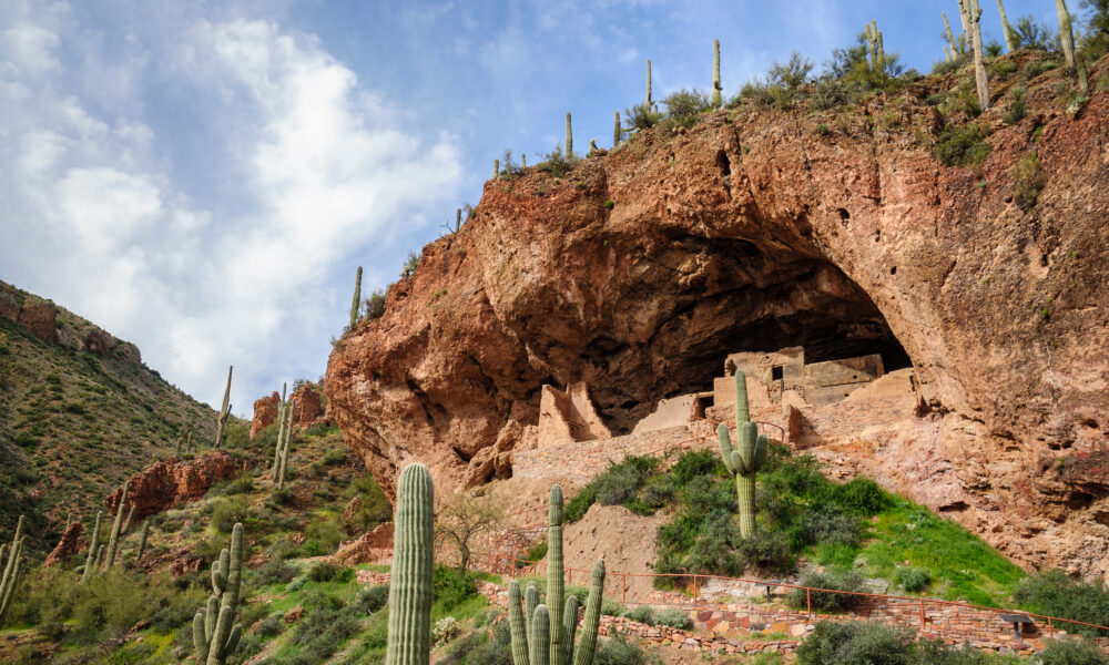

Tonto National Monument
The Ancient Salado People lived in this area from about 1250 CE to 1450 CE. Their name comes from the Spanish term for the Salt River – “Rio Salado.”
They built these natural cave-like shelters on hillsides, and today, you can see them for yourself at Tonto National Monument in Gila County, Arizona. Here are some interesting facts about the magnificent dwellings they left behind.

The Cliff Dwellings are Over 700 Years Old
The cliff dwellings at Tonto are architectural achievements that have survived seven centuries. Their placement offered natural protection from weather and enemies. It was also likely beneficial during winter due to their natural cave location, which provided protection from harsh weather and received morning sun, offering warmth.

They Built Walls with Cactus and Clay
They used natural cave alcoves as ready-made “roofs” for their homes. Their walls combined mud and rocks, specifically clay walls and rocks. They added strength using saguaro cactus ribs and sticks as reinforcement.
For support beams, they used pine and juniper, along with other local materials, to construct their dwellings, including roof beams.

The Lower Dwelling
You can experience ancient history without a difficult hike at the Lower Cliff Dwelling. A 1-mile round trip path takes you up to this well-preserved structure, gaining about 350 feet in elevation.
When you arrive, you’ll find a 16 room ground-floor with some second-story rooms and a neighbouring 12-room annex, and the Upper Ruin, which has a 32-room ground floor, a second story, and terraces and rooftop space where Salado families once lived.
Park staff are often around to explain how these spaces were used for living, storage, and group activities. The trail includes benches if you need to rest during your climb.

The Upper Dwelling
For a more in-depth adventure, head to the Upper Cliff Dwelling—but plan ahead. This larger structure with around 40 rooms requires a guided tour reservation. The three-mile round trip hike takes more effort than the Lower Dwelling trail, but you’ll see a more extensive ancient community.
Rangers limit groups of people, sharing details about Salado daily life and building methods. You’ll explore multi-story homes, storage areas, and community spaces far fewer visitors get to see.

Theories About Why the Salado Left
After living here for generations, the Salado suddenly left their cliff homes around 1450 AD. No one knows exactly why they disappeared after about roughly 100 years in this location. Scientists have several theories about why they left.
Evidence shows a severe drought hit the region, possibly making farming impossible. Other ideas suggest environmental factors like drought and floods, resource competition, and potential warfare, though the exact reasons remain a mystery.

Where the Word “Tonto” Comes From
Many scholars agree that the name Tonto derived from the Chiricahua name for Western Apaches — bini édiné — meaning “people without minds.” This may have referred to the fact that they spoke a different dialect.
Today,”Tonto” means “silly” in Spanish, a term Spanish settlers used for Apache groups in the region.
The name remained despite its unflattering meaning. The monument keeps this historical name while recognizing its problematic origins.

It Became a National Monument Thanks to President Roosevelt
President Theodore Roosevelt created this national monument in 1907 to protect remarkable cliff dwellings. Located in Gila County, Arizona, this 1,120-acre park preserves homes built by the Salado people about 700 years ago.

The Salado Made Beautiful Pottery
The Salado created beautiful art alongside their practical buildings. Their distinctive pottery featured geometric designs and animal shapes painted in red, black, and white. These vessels served as both useful containers and status symbols.
They also wove complex textiles from cotton grown in the valley below. They wove their textiles using looms, fastening vertical warp threads between two bars and interlacing horizontal weft threads.

Other Salado Sites May Have Existed in the Area
Roosevelt Dam’s completion in 1911 created the Theodore Roosevelt Lake, which flooded the Salt River valley where numerous Salado settlements once stood. Researchers believe dozens of additional Salado sites remain underwater today.
During droughts when lake levels drop, scientists sometimes get brief chances to study previously submerged areas.

Three Different Nature Areas in One Small Park
Despite covering just 1.8 square miles, Tonto National Monument contains remarkable biological diversity. The park includes a mix of desert scrubland, riparian areas, and even some higher elevation coniferous forests. This variety creates homes for many plants and animals.
The area showcases a transition zone between the upper Sonoran deserts of the Colorado Plateau and the lower Sonoran deserts of the Basin and Range province. The area is home to native animals such as whitetail and mule deer, mountain lion, bobcat, and various snakes.

The Big Forest Has More to Explore
The small monument sits within the massive Tonto National Forest, which offers many outdoor activities. At nearly 2.8 to 3 million acres, this is one of America’s largest national forests. Roosevelt Lake right next to the monument provides fishing, boating, and watersports.
Hikers can explore hundreds of miles of trails from easy walks to challenging backcountry routes. The 800-mile Arizona Trail passes nearby. You can also go mountain biking, horseback riding, or wildlife watching. Spring brings colorful wildflowers that create beautiful scenes against desert and mountain backdrops.
The post The Last Traces of Arizona’s Ancient Salado People Cling to These Remote Cliff Dwellings appeared first on When In Your State.