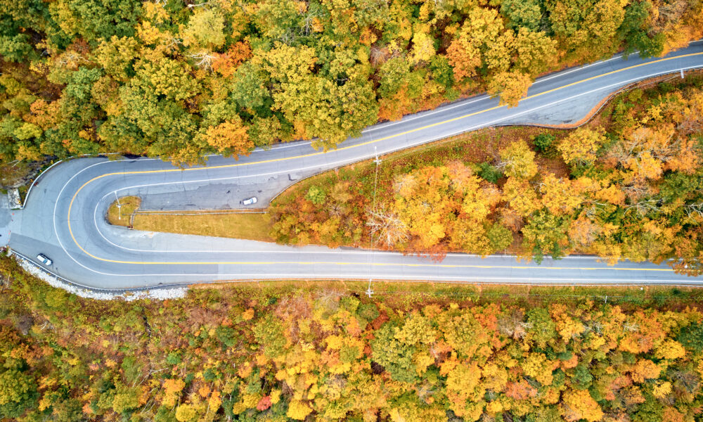
The Historic Mohawk Trail
The Mohawk Trail isn’t just Massachusetts’ first scenic road, it’s 63 miles of pure New England packed into a single route that opened on October 22, 1914.
Dating back to Native American trade paths, this historic stretch winds through the Berkshires’ most striking terrain, connecting old mill towns, dense forests, and epic valley views that made it famous way before cars existed.

Native Americans Carved the Trail
Native Americans made this trail by following paths that animals had created and the natural shape of the land.
Mohawk warriors gave the trail its name when they used it for trading and hunting.
People have found proof that native tribes used parts of this trail for at least 10,000 years, passing through the territories of tribes, such as the Pocumtucks and the Mahicans. They kept the path clear by burning plants along it, which helped them see better.

Building the Modern Road in 1914
Engineers had to solve big problems when they turned the trail into a road for cars. Their biggest challenge was building the “Hair Pin Turn” on Hoosac Range, which goes up 1,400 feet high.
Workers used explosives to break through rock and built strong walls to support this sharp turn. They also made special places where cars could stop to let their engines cool down after climbing the steep hills.

Sacred Places and Ancient Artifacts
Sites such as the Mohawk Trail State Forest feature dedicated areas like the Trees of Peace, Elder Grove, and Jani Memorial, which have been used for ceremonies by Native Americans in the past.
Artifacts such as arrowheads, pottery, and tools have been uncovered in the Berkshires region, revealing evidence of Native American occupation dating back to the late Archaic period (around 5000 years ago).

Historic Bridges and Their Stories
Two special bridges stand out along the trail. In 1908, the Bridge of Flowers in Shelburne Falls used to carry trolleys across the Deerfield River, but in 1929 people turned it into a walking bridge covered with gardens.
Near it stands the Iron Bridge from 1890 (the backdrop for the Annual Iron Bridge Dinner) shows how bridges were made in early America.
Both bridges are still used today.

The Highest Points on the Trail
The trail climbs from 580 feet at the Connecticut River in Greenfield up to Whitcomb Summit at 2,272 feet. From this highest point, you can see five different states when the sky is clear.
The big changes in height create small areas with their weather. You might feel the temperature drop by 15 degrees as you drive from the valley to the mountains. The summit is also known to host the Elks Memorial, commemorating World War I veterans.

Glaciers Shaped the Land
The Connecticut River Valley was once submerged under Glacial Lake Hitchcock, which existed approximately 14,000 years ago before draining and shaping the fertile valley.
In the Hoosac Range Reserve, hikers can observe sizable erratics carried by these huge ice sheets over 10,000 years ago.
Natural Bridge State Park (home to North America’s only natural white marble arch) is another example formed from 550-million-year-old bedrock marble and shaped by glacial meltwater over 13,000 years ago.

Role in Early American Wars
The trail became very important during the French and Indian War between 1754 and 1763. British soldiers built several forts along it, including Fort Massachusetts in North Adams, to protect the early settlements.
During the American Revolution, Benedict Arnold traversed this route on his way to Fort Ticonderoga. You can still see some of the original markers and signs that show where these old forts and battles were.

Hidden Waterfalls You Can Visit
Several beautiful waterfalls lie along the trail, like Tannery Falls in Savoy Mountain State Forest, which drops 80 feet and splits into different streams when there’s lots of water.
The park’s 40-foot Parker Brook Falls originates from Shakey Pond east of Borden Mountain. At Phelps Falls, you can find a natural water slide in summer.
If you follow unmarked paths along Cold River, you’ll discover more waterfalls where you can swim and take pictures away from the crowds.

Rare Plants That Grow Here
The oldest eastern hemlock in the state grows along this trail dating back over 500 years. As you enter the Savoy Mountain State Forest, you’ll observe extremely tall eastern white pines.
There are at least 146 of these pines reaching a height of 150 feet or more. Yellow lady’s slipper orchids can be found in damp woods along the Deerfield River valley, especially in spring and early summer.
High up, boreal forests along the Mohawk Trail support mountain ash trees, which produce bright red berries that waxwings and robins eat in winter.

Original Markers That Tell Tales
You’ll still find stone milestones from earlier periods (pre-automobile era) along parts of the route. Some have pictures carved into them showing local landmarks or Native American designs.
The Whitcomb Summit along the trail, at 2,272 feet, was a popular rest stop for early motorists due to the challenging incline.
In North Adams, the “Hail to the Sunrise” statue, dedicated in 1932, commemorates the Mohawk people who once traveled the route.

Rock Layers From the Ice Age
The rocks along the trail tell stories from hundreds of millions of years ago.
You can see schist and gneiss rocks that formed when the Appalachian Mountains were created, about 450 million years ago.
At the western end, limestone rocks (such as the Stockbridge Marble) contain fossils from sea creatures that lived here when this area was under a warm ocean.
The Greylock Schist on Mount Greylock consists of muscovite, chlorite, and quartz schist.

Wildlife Encounters During the Trail
White-tailed deer are commonly seen grazing along the roadside or within clearings at dawn and dusk.
You might spot a bald eagle soaring above Deerfield River and at night eastern screen owls camouflage in the woodlands.
Hikers have also encountered northern water snakes, spotted salamanders, and eastern box turtles near water bodies.
Monarch butterflies migrate through this trail in late summer and early fall.
The post The Massachusetts Highway Where Hairpin Turns Meet 340-Year-Old Native American History appeared first on When In Your State.


![Tyson Foods Plant [Photo: Food Manufacturing]](https://southarkansassun.com/wp-content/uploads/2023/08/iStock_1185520857__1_.5e441daa51cca-600x337.jpg)


![Silverado Senior Living Management Inc. [Photo: Los Angeles Times]](https://southarkansassun.com/wp-content/uploads/2023/10/download-6-4-600x337.jpg)

![China's Wuhan Institute of Virology [Photo: Nature]](https://southarkansassun.com/wp-content/uploads/2023/09/d41586-021-01529-3_19239608-600x337.jpg)


