


![Tyson Foods Plant [Photo: Food Manufacturing]](https://southarkansassun.com/wp-content/uploads/2023/08/iStock_1185520857__1_.5e441daa51cca-600x337.jpg)


![Silverado Senior Living Management Inc. [Photo: Los Angeles Times]](https://southarkansassun.com/wp-content/uploads/2023/10/download-6-4-600x337.jpg)

![China's Wuhan Institute of Virology [Photo: Nature]](https://southarkansassun.com/wp-content/uploads/2023/09/d41586-021-01529-3_19239608-600x337.jpg)


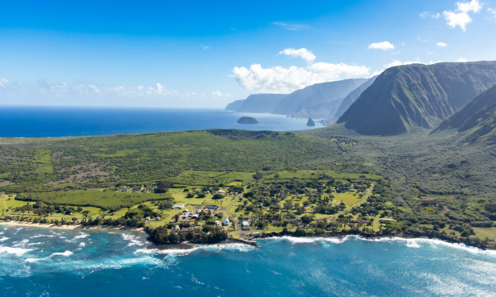

The Complex History of the Kalaupapa Peninsula
Kalaupapa Peninsula sits on Molokai’s northern coast, cut off from the world by towering sea cliffs and rough waters. From 1866 to 1969, this isolated spot was Hawaii’s leprosy settlement, where thousands lived and built their community.
Today, it’s both a National Historical Park and home to a handful of former patients who chose to stay.

It’s Hidden Behind the World’s Highest Sea Cliffs
The cliffs next to Kalaupapa rise over 3,000 feet high, taller than any other sea cliffs on Earth. These massive walls, which Hawaiians call pali, formed 1 to 1.5 million years ago from ancient volcanic activity and years of erosion.
When the weather is clear, you can watch waterfalls pour down these giant cliffs. The walls create a stunning backdrop that reminds everyone of how remote this place is.

Kalaupapa’s Leper Colony
Kalaupapa served as a leprosy settlement from 1866 to 1969, isolating over 8,500 individuals diagnosed with Hansen’s disease. Established under King Kamehameha V, it was chosen for its inaccessibility due to the wall of sea cliffs.
The first patients arrived in January 1866, facing dire conditions without adequate shelter or resources. Notable figures like Father Damien and Mother Marianne Cope provided care and improved living conditions.
The colony was officially closed in 1969, but a few former patients chose to remain.

The Graves of the Kalaupapa Peninsula
About 1200 marked graves lie across the Kalaupapa Peninsula, with several hundred unmarked graves, totaling around 8,000 individuals who died here.
Hawaiian burial grounds were here long before the colony, and more cemeteries were added later. Different churches: Catholic, Protestant, and Mormon, had separate burial grounds.
The biggest (called Fields of the Dead) is next to St. Philomena Church in Kalawao, where rows of crosses and markers cover the ground.

The Peninsula Was Born from a Volcanic Eruption
A volcano erupting underwater formed Kalaupapa Peninsula about 230,000 years ago. This created the flat piece of land that now sticks out from Molokai’s tall sea cliffs.
You can still see the volcanic crater called Kauhakō, which rises 500 feet (about 152 meters) above the ocean. The dark volcanic soil of the peninsula looks very different from the old, worn-down cliffs of Molokai.

It’s Incredibly Remote
There are only three ways to reach Kalaupapa. You can hike down a steep trail that zigzags 26 times and drops 1,700 feet. The hiking trail runs 3.5 miles long, and each turn gives you a better view of the peninsula below. You can fly in on a commuter plane from Oʻahu and Hoʻolehua, Molokai, to Kalaupapa Airport (LUP).
Those considering a boat will need a special use permit to approach within a quarter-mile of the Kalaupapa shoreline by boat.

Life in Ancient Hawaiian Times
Before it became a colony, Kalaupapa had two busy Hawaiian villages. People lived in Kalawao on the east side and Kalaupapa on the west side. These villages started between 1300 and 1400 AD. Hundreds of people lived here and grew taro in the rich soil, utilizing fishponds to supplement their diet.
They built stone walls, platforms for houses, and places of worship. The population had drastically declined to about 140 individuals by 1853.

Hundreds of Deer Roam on Kalaupapa
Axis deer have lived on Kalaupapa since the 1860s when they were brought to Molokai. With an estimated 50,000 to 70,000 individuals as of 2021, you’ll see them eating grass near buildings and open fields.
Look for them early morning and late afternoon, when they move around in small groups. Today, perimeter fences have been constructed around the Kalaupapa Peninsula to keep axis deer out of sensitive and unique habitats.

Hawaii’s Longest Ocean Pier
The Kaunakakai Pier, on Molokai’s southern shore, is the longest in Hawaii, extending 1,900 feet into the Pacific Ocean. The existing harbor facilities at Kalaupapa were completed in 1967 at a total federal cost of $158,000.
Ships used this pier to bring in supplies and the occasional visitor when the seas were rough. During the calm summer months, boats can still dock here.

Under Kalaupapa is a Lava Tube
The Kauhako Trench, a collapsed lava tube, approximately one mile in length running north from Kauhako Crater, features vegetation protected from wind and ocean spray.
The Kaupikiawa Cave System (located on the northeast flank of Pu‘u‘uao) is another unique underground formation that runs under Kalaupapa.
Early Hawaiians used some caves for storage and shelter, while others became burial places.

Natural Springs Feed the Land
Natural springs made it possible for both ancient Hawaiians and colony residents to live on this isolated peninsula. Fresh water flows from several springs around Kalaupapa, some of which come up right near the ocean’s edge.
The biggest called Waihanau, still provides water to people living here today. Additionally, steel reservoir tanks for a new spring-fed water system were installed in 1982 in Waihanau Valley.

A Post Office That Still Works
The Kalaupapa post office building, completed in 1934, is one of America’s most isolated mail stops (over 140 years of service). It also housed the Kalaupapa Courthouse on its far right end.
Mail arrives by mule train or small airplane for the people who still live and work here. Every letter that passes through gets a special Kalaupapa postmark that many collectors want.
The post This is Hawaii’s Former Leprosy Colony, Where 8,000+ Patients Were Isolated Behind the World’s Tallest Sea Cliffs appeared first on When In Your State.