


![Tyson Foods Plant [Photo: Food Manufacturing]](https://southarkansassun.com/wp-content/uploads/2023/08/iStock_1185520857__1_.5e441daa51cca-600x337.jpg)


![Silverado Senior Living Management Inc. [Photo: Los Angeles Times]](https://southarkansassun.com/wp-content/uploads/2023/10/download-6-4-600x337.jpg)

![China's Wuhan Institute of Virology [Photo: Nature]](https://southarkansassun.com/wp-content/uploads/2023/09/d41586-021-01529-3_19239608-600x337.jpg)


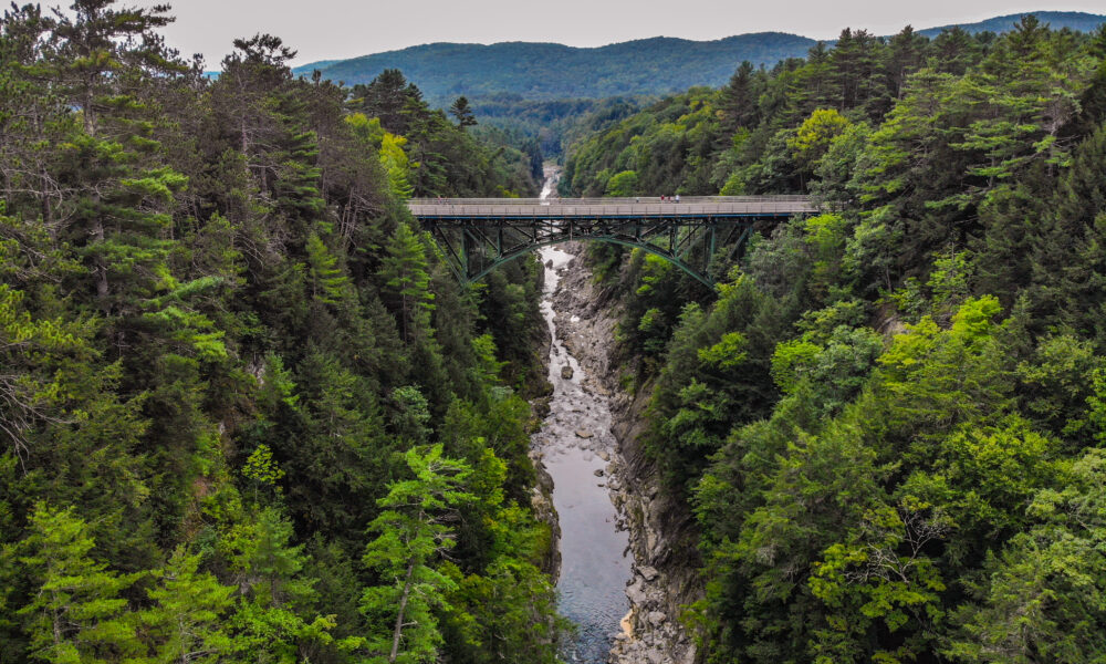

The Quechee Gorge, Vermont
At Quechee Gorge, Vermont shows off what water and ice can do with enough time. The 165-foot gorge cuts through ancient rock, with the Ottauquechee River still flowing below. Hit the viewing bridge for the quick photo, but the hiking trails and swimming spots are where you’ll want to spend your time.

How Ice Age Glaciers Created the Gorge
During the last ice age, huge glaciers covered New England. When these ice sheets melted and moved north, the rushing water cut through layers of rock to form the first channel.
Over thousands of years, the Ottauquechee River kept carving deeper into the rock made of schist and gneiss. Today, you can see clear lines and patterns in the steep walls, and some of these rock layers are more than 300,000 years old.

The Railroad Bridge That Became a Walkway
In 1911, workers built a steel bridge across the gorge for the Woodstock Railroad. The bridge stretches 285 feet across and sits 165 feet above the river. Though trains and cars once used this bridge, now it’s a path where you can walk and enjoy the view.
The bridge rests on large stone supports that came from Hartford Quarry nearby. These supports are so strong they can hold up to about 90 tons. While the bridge still has its original steel parts, it now includes modern safety features and viewing spots.

What Birds and Animals Live in the Gorge
Every spring, peregrine falcons come back to nest in the same cliff spots they’ve used for generations. In the water below, brook trout and chain pickerel swim freely, and sometimes otters play in the quiet morning hours.
If you look up, you might see red-tailed hawks, turkey vultures, and sometimes even golden eagles soaring through the gorge. The steep cliffs are also home to several types of rare moss and lichen that grow well in the gorge’s protected walls.

Small Waterfalls Hidden Around the Gorge
Near the main gorge, you’ll find many smaller waterfalls along streams that feed into the river. Some waterfalls drop gently for a few feet high, while others plunge dramatically for about 20 feet. In spring, when snow melts, these falls turn into powerful streams that move millions of gallons of water each day.
The rushing water has carved out its own mini-gorges over time, creating a series of pools and rapids. The most impressive of these hidden falls are along the northern streams, where spring water flow can be ten times stronger than usual.

How the Abenaki People Used the Gorge
The Abenaki people hunted and fished around the gorge for more than thousands of years. Archaeologists have found stone tools, fishing gear, and cooking sites around the area near the gorge.
The name “Ottauquechee” comes from Abenaki words meaning “swift mountain stream.” To the Abenaki, this wasn’t just a place to find food – it was a sacred spot that played an important role in their stories about how the land was made.

What You Can Do Here in Every Season
Each season brings something special to the gorge. In summer, you can swim in hot pools, while winter lets you climb huge walls of frozen ice. Fall turns the gorge into a rainbow of red and gold leaves that reflect in the walls.
When spring comes, a wide variety of birds return, and new waterfalls appear as snow melts. You can choose from easy walks or challenging hikes on well-kept trails on both sides of the gorge.

The Natural Pools Perfect for Swimming
At the bottom of the gorge, several pools have formed where the water has swirled for hundreds of years. The main pool is pretty wide and thanks to the gorge’s walls blocking strong winds, these pools stay around 72 degrees all summer.
Smooth rocks around the pools make perfect spots for sunbathing. The water is so clear you can see down 20 feet, making it easy to watch native fish swimming below the surface.

Where You Can Find Old Mill Remains
As you walk along the gorge’s edge, you’ll spot pieces of history from the 1789 Hartford Woolen Mill. Stone channels that once carried water to power the mill’s machines still cut across the land. Look carefully along the trails and you might find old millstones and iron parts.
The best-preserved piece is a 25-foot section of the old mill’s water channel, where you can still see marks left by the workers’ tools.

Why Sounds Echo So Much in the Gorge
The tall rock walls make sounds bounce and get louder – the sound of rushing water can be up to four times louder than normal when the river is high. Different parts of the gorge create different sounds, from low rumbles to high whistles.
How the sounds travel changes with water levels and weather. Sound can carry for over half a mile through the gorge. Early in the morning, you might hear peregrine falcon calls bouncing off the walls.

The Different Layers of Rock Tell Earth’s Story
Each stripe in the gorge walls shows a different time in Earth’s history, going back millions of years. Some limestone layers hold fossils from ancient sea beds, while crystal stripes show where intense heat and pressure changed the rock.
The most interesting marks are long parallel scratches that show exactly which way the ice moved during the last ice age. These scratches point northwest to southeast, carved by rocks stuck in the bottom of moving ice sheets.

Ottauquechee River Streamflow
The Ottauquechee River is experiencing high streamflow at 234% of normal, with an expected yield of 3,396 acre-feet of water. The highest stage is at North Hartland with a gauge stage of 5.09 feet and 1,550 cfs.
A peak of 5,531 cfs was recorded on July 13, 2023. The river is monitored by two stream gauging stations, with the highest at 1,160 feet near West Bridgewater. As of January 2025, the flow is 108 cfs, making it somewhat fishable for wade anglers.
The post This 165-Foot Deep Chasm is Known as Vermont’s “Little Grand Canyon” appeared first on When In Your State.