


![Tyson Foods Plant [Photo: Food Manufacturing]](https://southarkansassun.com/wp-content/uploads/2023/08/iStock_1185520857__1_.5e441daa51cca-600x337.jpg)


![Silverado Senior Living Management Inc. [Photo: Los Angeles Times]](https://southarkansassun.com/wp-content/uploads/2023/10/download-6-4-600x337.jpg)

![China's Wuhan Institute of Virology [Photo: Nature]](https://southarkansassun.com/wp-content/uploads/2023/09/d41586-021-01529-3_19239608-600x337.jpg)


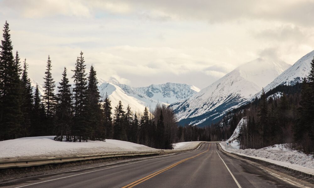

Alaska’s Breathtaking Roadway, Alaska
The Seward Highway stretches 127 miles from Anchorage to Seward, cutting through some of Alaska’s most beautiful landscapes. Workers built this road in 1951, carefully placing it between the mountains of Chugach National Forest and the waters of Turnagain Arm. The U.S. government named it an All-American Road and National Scenic Byway in 2000 because of its outstanding views.
Also known as Alaska Route 1, this vital road connects communities and welcomes millions of visitors each year who come to see its stunning mountain peaks, pristine waters, and abundant wildlife.Also known as Alaska Route 1, this vital road connects communities and welcomes millions of visitors each year who come to see its stunning mountain peaks, pristine waters, and abundant wildlife.

How Glaciers Shaped the Highway’s Path
Huge glaciers from the last ice age carved out the route that the highway follows today. These massive rivers of ice, which flowed through the area thousands of years ago, created the deep valleys and steep cliffs that now rise above the road.
The section along Turnagain Arm shows the power of these ancient glaciers – one glacier here was thicker than thirteen football fields stacked on top of each other. When road crews built the highway, they had to work around giant boulders and deep layers of rock that these glaciers left behind.

Spectacular Waves Form Twice Daily in Turnagain Arm
Between Bird Point and Girdwood, you can watch an amazing natural show called a bore tide. When incoming tides meet outgoing water in the narrow channel, they create waves as tall as a one-story house that travel up to 15 miles.
These powerful waves move as fast as a person running, bringing excitement to locals and visitors who gather at viewing areas along the road. You can set your watch by these waves since they appear exactly 11.5 hours after the last high tide, making this spot one of the most reliable places in the world to see bore tides.

Winter Brings Record Amounts of Snow to Thompson Pass
At Mile 45, Thompson Pass gets more snow than almost anywhere else on the highway. Snow plows work around the clock in 12-hour shifts during winter months to keep the road open for travelers.
The winter of 1952-53 set an incredible record when 974.1 inches of snow fell here – that’s taller than three football fields standing on end. Special snow blowers clear the road by shooting snow 150 feet away, about half the length of a football field, while drivers sometimes can barely see 10 feet ahead during storms.

Wildlife Owns the Seward Highway
The road connects different parts of Chugach State Park to the Kenai Peninsula, creating a path that many animals use for travel. In spring, between April and May, you might see Dall sheep with their new lambs on the cliffs above Windy Point.
From July through August, beluga whales chase salmon in Turnagain Arm, while black bears and moose cross the highway during their seasonal moves to find food. Mountain goats live high up near Crow Pass, and a number of different types of birds, including bald eagles and arctic terns, build nests along the road.

Building the Highway Was Dangerous, Too
Construction teams had to blast through solid rock and build strong bridges over fast-moving streams, while also finding ways to build on permanently frozen ground.
Workers hung from ropes on steep mountainsides to place explosives, often working in temperatures cold enough to freeze mercury. The project needed more than 200 large drainage pipes and many bridges, with some stretching longer than 100 feet to cross wide gaps.

Dangerous Mudflats Appear During Extreme Tides
The waters along Turnagain Arm rise and fall dramatically, creating some of the biggest tide changes in North America. Only Canada’s Bay of Fundy has larger tides than the 40-foot difference you can see here.
When the tide goes out, it exposes mudflats that stretch out for a mile, but these mudflats can be deadly. The fine, glacial mud acts like quicksand, which is why warning signs line the highway and rescue teams stay ready nearby during tourist season.

The Path Once Led Gold Seekers to Their Dreams
Before cars drove on this highway, gold miners walked or used dog sleds on these same trails in the late 1800s. Their journey, which now takes hours by car, could take weeks on foot.
Near the old mining town of Hope, you can still spot leftover mining equipment from those days. Old water cannons and wooden channels that miners used to separate gold from dirt still sit where workers left them, telling stories about Alaska’s gold rush days.

The Avalanche Danger is Real
In winter, places along the highway could have avalanches, especially near Mile 37 in the Kenai Mountains. These snow slides can pile up snow as deep as a three-story building across the road.
The highway department uses special weather stations and sensors to watch for danger signs. When conditions look risky, they can quickly close parts of the road using special gates to protect drivers from avalanches that can move as fast as a race car.

Some of the Rocks Are Millions of Years Old
At Bird Point, you can see rocks that were once part of the ocean floor millions of years ago. The highway cuts through places where three of Earth’s major plates come together. These ancient rocks got pushed up to the surface over time.

Railroad Tracks Run Alongside the Road
The Alaska Railroad has followed this route since 1903, running next to the highway for many miles. In some places, trains and cars pass within 50 feet of each other as they squeeze between mountains and ocean.

Beauty Through the Seasons
Every autumn, usually from late August through September, the mountains put on a beautiful show of colors. The change starts between 1,500 and 3,000 feet up the mountainsides, where small plants turn from green to bright red and gold.
Fireweed plants, which grow thick along the southern parts of the highway, change from pink flowers to deep red leaves. This colorful display typically lasts about a month as small birch and willow trees in higher areas also turn golden.

Marine Animals Are Visible from the Road
For 50 miles along Turnagain Arm, you can often spot sea animals right from your car, making this highway special among major roads in North America. Harbor seals follow the tides looking for fish, especially during spring when small fish called eulachon swim upstream.
In summer, between July and September, sea lions chase salmon through the churning water. The road has many pullouts where you can safely stop to watch these animals, with signs that tell you what to look for and the best times to see different species.
The post Alaska’s Deadliest Beautiful Drive Hugs Cliffs Where Tides Rise Faster Than Humans Can Run appeared first on When In Your State.