


![Tyson Foods Plant [Photo: Food Manufacturing]](https://southarkansassun.com/wp-content/uploads/2023/08/iStock_1185520857__1_.5e441daa51cca-600x337.jpg)


![Silverado Senior Living Management Inc. [Photo: Los Angeles Times]](https://southarkansassun.com/wp-content/uploads/2023/10/download-6-4-600x337.jpg)

![China's Wuhan Institute of Virology [Photo: Nature]](https://southarkansassun.com/wp-content/uploads/2023/09/d41586-021-01529-3_19239608-600x337.jpg)


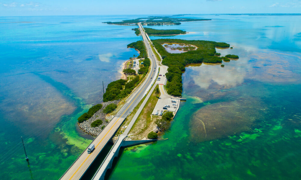

The Overseas Highway, Florida Keys
The Overseas Highway strings together the Florida Keys like a 113-mile necklace of asphalt, hopping from island to island over impossibly blue water. It was originally a railway built by Henry Flagler (aka the Father of Modern Florida) until a massive hurricane destroyed it in 1935.
Today, this stretch of US-1 makes you work for those Key West sunsets, crossing 42 bridges – including the famous Seven Mile Bridge – with ocean views in every direction.

The Seven Mile Bridge
It isn’t quite seven miles long, but actually 6.765 miles end to end. The Overseas Highway’s construction took about 2 years (1937–1938), starting with the reconstruction of the rail lines into a roadbed.
Engineers made it strong enough to handle both boat crashes and hurricane winds up to 200 miles per hour. Today’s bridge runs next to the old one that Henry Flagler originally built for his Florida East Coast Railway. The bridge stands 65 feet above the water so boats can pass underneath.

It Used to Be Made of Wood
The first Overseas Highway in the 1920s used wooden bridges (about 10 feet wide) to connect some of the smaller islands.
These bridges were made from pine and cypress trees. Saltwater kept damaging the wood, so workers had to fix the bridges every month and replace about 50 wooden planks each week. They were later replaced with concrete after getting heavily damaged by the 1935 Labor Day Hurricane.

Toll Removal Changed the Keys
People had to pay to use the Overseas Highway from 1938 to 1954, spending 35 cents (equivalent to about $6 in today’s money) to cross each bridge. When the tolls went away, it changed how people visited the Florida Keys forever.
Getting rid of the tolls worked well for tourism as visitors jumped from 50,000 to 150,000 in just one year. This change transformed the Keys from farming communities into popular vacation spots.

World’s Only Underwater Road Crossing
In the Upper Keys at Tea Table Channel, you’ll find an abandoned road that lies beneath the modern highway, deep in the ocean. The old highway lies 20 feet underwater and crosses the new road at a 30-degree angle.
This underwater crossing is home to more than 50 types of fish and coral species that grow on the old concrete road pieces. When the tide is low, you can spot about 200 old railroad supports and bridge pieces from Flagler’s Florida East Coast Railway in the water.

Natural Features That Protect the Highway
The road follows the natural curve of old coral reefs that formed more than 100,000 years ago. These reefs (part of the third-largest barrier reef system in the world, the Florida Reef Tract), along with shallow waters only 6 to 12 feet deep, help reduce damage from big waves during storms.
Dense mangrove forests covering 1,800 acres also protect the highway. Their thick root systems block up to 90% of storm surge energy.

Birds Made the Bridge Their Home
A 2.2-mile stretch of the old Seven Mile Bridge has turned into an important place for sea birds to nest. Every year, brown noddies, frigatebirds, and roseate spoonbill make their nests here.
The old bridge works perfectly as a bird sanctuary because it stands 35 feet above the water, keeping the birds safe from predators. Protected by the Florida Keys National Wildlife Refuge, other species like laughing gulls and black skimmers also use the old bridge for nesting.

Film Crews Love the Highway
Over 150 productions have used the highway as a backdrop, starting in the 1940s. The Overseas Highway was used in some of the earliest “road trip” films and productions in the mid-20th century.
When people see aerial shots of the highway in movies or TV shows, they immediately recognize it as Florida. The Seven Mile Bridge is featured in films such as True Lies (1994) with Arnold Schwarzenegger, and it also appeared in 2 Fast 2 Furious (2003).

Moving Bridges That Flex with Nature
The concrete bridges can move up to 18 inches during bad weather without getting damaged. Special joints placed every 36 feet let the bridges bend and stretch as needed.
Hot and cold weather make the bridges expand and shrink by up to 6 inches each day. Wind and waves also make the bridges sway slightly, though only accelerometers and strain gauges can detect even the smallest movements in the bridge.

Trees That Help Mark Highway Miles
The scent of saltwater mingles with the breeze, as mangroves line the shores, their roots twisting like natural sculptures. The highway uses native buttonwood trees and palm trees as natural mile markers alongside the regular green signs.
These living landmarks help emergency teams find locations quickly when they need to help people. This system comes from the old days when sailors used special trees and coastline shapes to find their way around the Keys.

Special Lights That Guide Night Drivers
The highway has 5,300 markers spaced 50 feet apart along sections that cross water. These markers use special reflectors that stay visible even in rain and ocean spray, making night driving safer.
New solar-powered markers installed in 2018 collect sunlight during the day and light up at night (accidents have dropped by 40% since installation).

The Highway Ends With a Key West Sunset
The highway culminates in Mallory Square, a lively waterfront hub where locals and tourists gather to celebrate the evening’s vibrant sunsets. This section has wider shoulders between 10 and 15 feet so people can safely pull over.
As you cross the Seven Mile Bridge, the turquoise waters of the Gulf of Mexico stretch endlessly, reflecting the orange and pink hues of the setting sun, against the the distant sound of swaying palm trees.
The post The Historic Florida Highway Where You’re Surrounded by Water Almost the Entire Drive appeared first on When In Your State.