


![Tyson Foods Plant [Photo: Food Manufacturing]](https://southarkansassun.com/wp-content/uploads/2023/08/iStock_1185520857__1_.5e441daa51cca-600x337.jpg)


![Silverado Senior Living Management Inc. [Photo: Los Angeles Times]](https://southarkansassun.com/wp-content/uploads/2023/10/download-6-4-600x337.jpg)

![China's Wuhan Institute of Virology [Photo: Nature]](https://southarkansassun.com/wp-content/uploads/2023/09/d41586-021-01529-3_19239608-600x337.jpg)


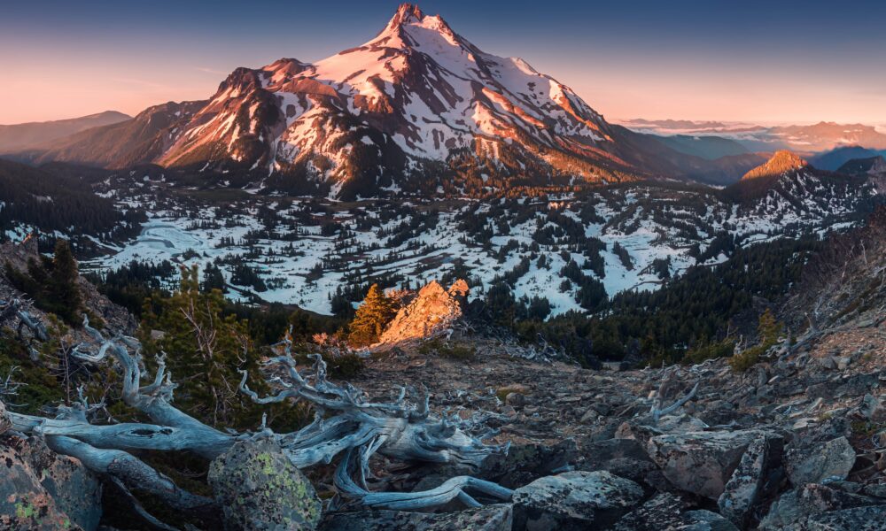

Climbing Oregon’s Mount Jefferson
The 10,497-foot Mt. Jefferson is no walk-up. While Hood gets the crowds and Sisters has the views, Jefferson combines glacier crossings, loose rock, and complicated approaches into one of Oregon’s most challenging climbs. Here’s what you’re getting into.

When to Plan Your Climb
July through September brings the best climbing weather, as melting snow reveals important route markers and dangers. During these months, the temperature stays between 40-70°F, with August having the least rain.
Starting before sunrise helps you avoid afternoon thunderstorms that often form over the peak. Climbing during weekdays means you’ll see fewer people on the mountain, especially at popular spots like Scout Lake.

How to Get Required Permits
You need a Mount Jefferson Wilderness permit whenever you visit the area. From October to May, you can get these permits yourself at the main trailheads. You’ll also need a Northwest Forest Pass to park your car.
Keep your group size at 12 people or less to protect the environment. Set up camp at least 100 feet from water sources, and don’t make fires above 5,500 feet.

What Skills You Need
You must know how to walk on glaciers, rescue people from cracks in the ice, and stop yourself with an ice axe if you fall. Working well with a rope team and knowing where to place safety gear are key skills.
Reading weather signs helps you decide when it’s safe to reach the top. Since whiteout conditions happen often, you need to be good with maps and compass work. Try climbing other Cascade volcanoes first to build experience.

What Gear to Bring
Pack essential climbing tools: crampons, ice axe, helmet, and harness. Bring a 60-meter rope for glacier travel and emergency situations.
Wear layers of non-cotton clothes that work well in different weather. Carry a map, compass, and GPS for finding your way. Don’t forget emergency shelter, first aid supplies, and at least 3 liters of water per person.

Where the Main Route Goes
The South Ridge Route begins at Pamelia Lake trailhead and covers 12 miles round trip. You’ll climb 6,000 feet from start to summit.
Finding the right way gets harder above the treeline. The serious climbing starts at 9,000 feet. Watch for falling rocks at Red Saddle, and choose your path carefully near the top.

What Makes the Mountain Dangerous
Rocks often fall from above, especially near the summit. Hidden cracks in the glaciers pose risks all year, while afternoon lightning can strike without warning.
The weather can change in minutes, making it hard to see where you’re going. Loose volcanic rock can break away under your feet, and snow bridges might collapse when you cross them.

How to Handle Emergencies
Let someone reliable know your climbing plans and when you’ll return. While cell phones sometimes work on the south side, bring a satellite device for better emergency contact.
Know several ways down the mountain before you start up. Learn to spot signs of altitude sickness, like headaches and confusion, and carry emergency shelter and extra food.

Where to Camp
You can set up camp at Jefferson Park’s designated spots at 5,500 feet. In good conditions, you can also camp on snow above the treeline.
Scout Lake offers the last reliable water before the hard climbing begins. Winter camping needs special gear like sturdy tents and snow anchors.

How Weather Affects the Mountain
The mountain creates its own weather patterns, often different from nearby valleys. Early morning usually brings the most stable conditions before heat disturbs the snow and rocks.
Strong winds often blow above the treeline. For every 1,000 feet you climb, the temperature drops.

How to Get in Shape
Your body needs to handle walking uphill for hours while carrying a heavy pack. Train by hiking steep trails with a loaded backpack.
Spending time at high altitudes before your climb helps your body adjust. Start with easier peaks and gradually work up to more challenging ones.

How to Stay on Route
Look for key landmarks like Pamelia Lake, the Pacific Crest Trail crossing, and Red Saddle. Rock piles mark the trail below the treeline, but these become hard to find in the snow.
Check recent photos and reports of the route before you climb. Know how to use a map and compass when clouds block your view.

Where to Find Water
You can filter water at Pamelia Lake and Scout Lake. After that, you’ll need to melt snow for drinking water.
Carry at least 3 liters per person. Always treat water before drinking it, even from clean-looking sources.
The post Climbing Oregon’s Most Technically Difficult Mountain – What You Need to Know appeared first on When In Your State.