


![Tyson Foods Plant [Photo: Food Manufacturing]](https://southarkansassun.com/wp-content/uploads/2023/08/iStock_1185520857__1_.5e441daa51cca-600x337.jpg)


![Silverado Senior Living Management Inc. [Photo: Los Angeles Times]](https://southarkansassun.com/wp-content/uploads/2023/10/download-6-4-600x337.jpg)

![China's Wuhan Institute of Virology [Photo: Nature]](https://southarkansassun.com/wp-content/uploads/2023/09/d41586-021-01529-3_19239608-600x337.jpg)


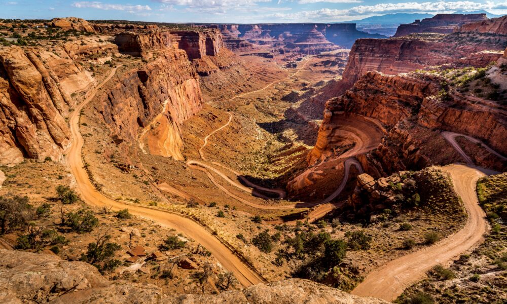

Driving the White Rim Road, Utah
White Rim Road is a 100-mile dirt road that circles through the Canyonlands National Park in Utah, running between the Colorado and Green Rivers, 1,200 feet above sea level. The road was first built to support uranium mining in the 1950s but is now used by adventure travelers.
Today, you can access the route at the Shafer Trailhead or Potash Road, both accessible from Moab. Here’s everything you need to know for an exciting (and informed) trip ahead.

Get a White Rim Road Permit
The National Park Service releases permits at 8:00 AM Mountain Time, four months before your travel date. These permits often sell out within five minutes during spring (March-May) and fall (September-October).
For day-use permits, 25 are available online (up to 24 hours), while the remainder can be obtained at the visitor center. You can reserve overnight backcountry permits up to six months before your travel dates.
The park allows only 50 vehicles per day to protect the environment and prevent overcrowding.

How Long is the Route?
While it’s possible to drive this 100-mile loop in 15 hours straight, most people take 2-4 days to enjoy the journey.
Cars with four-wheel drive usually cover 25-30 miles each day, and cyclists typically ride 15-20 miles. The slow pace lets you stop at scenic spots like Musselman Arch, Washer Woman Arch, and Monument Basin.
Your daily distance will depend on the weather, your vehicle’s capabilities, and how many people are in your group.

What Kind of Vehicle You Need
You must have a four-wheel-drive vehicle with at least 9 inches of ground clearance. Regular SUVs and crossovers aren’t tough enough for this road. Your vehicle needs a matching spare tire, a high-lift jack, and traction boards to get unstuck.
The road has steep hills with 12% grades, large rocks, and deep sand. Since there are no gas stations along the route, bring at least 10 extra gallons of fuel.
Most adventure enthusiasts generally carry additional recovery gear, such as winches or tow straps.

Bring Lots of Water (For Real)
There’s no drinkable water anywhere along the 100-mile route. The closest water source is at the Island in the Sky visitor center.
Each person needs one gallon of water per day for drinking and cooking, plus extra for emergencies and cleaning. In summer, when temperatures rise above 100°F by noon, you’ll need at least 1.5 gallons daily.
Use hard plastic containers instead of water bags, and pack them carefully so they don’t break or leak on the bumpy road.

Plan According to the Weather
Spring (March-May) and fall (September-November) are best, with temperatures between 60-80°F. But sudden rainstorms can drop a half-inch of rain in just 30 minutes.
Summer days are often above 100°F with the risk of flash floods, while winter brings in snow. The road closes when it receives a quarter-inch of rain as vehicles can get stuck for up to three days.
Check the weather forecast for both the Needles District and Island in the Sky areas before your trip.

How to Navigate White Rim Road
The main road follows the rim’s edge. But there are a few detours (Lathrop Canyon, White Crack, and Labyrinth Canyon) that people find confusing.
Bring a GPS device and paper maps with a compass, as the canyon walls can block satellite signals for up to an hour. Trail junctions are marked with three-foot-tall rock piles called cairns, which can be hard to see in shifting sand or shadows.
The landscape looks very different in morning and afternoon light. Study the road’s four main sections before you start, and check your location every hour.

Best Camping Spots Along White Rim Road
There are 20 official campsites along the road. Airport Campground has great views but strong winds, while Potato Bottom is close to the river but gets very hot in summer.
These sites have no toilets, tables, or shade structures. Each site allows only one to three vehicles, and you must camp on durable surfaces to protect the fragile desert soil.
You must pack out all trash, and fires aren’t allowed at any time, so bring a camp stove or plan for meals that don’t need cooking.

What Wildlife Encounters to Expect
Desert bighorn sheep often cross the road between Murphy’s Hogback and Hardscrabble Hill. Golden eagles nest in the high cliffs from February through July. At night, you might see ringtail cats and Great Basin rattlesnakes near your campsite.
Keep all food in hard containers because ravens know how to unzip tent bags. Stay at least 100 feet away from any animals you see, as there are no rangers nearby to help if something goes wrong.

Skills Needed for Driving the Road
Murphy’s Hogback has a steep 16% grade with tricky turns, and Hardscrabble Hill combines loose rocks with tight turns. Vehicles with higher clearance and shorter overhangs are better suited.
You’ll need spotters to navigate the steep sections. Vehicles longer than 15 feet need to make three-point turns here. Most drivers lower their tire pressure to 20 PSI for better grip, but you’ll need an air compressor that can reach 150 PSI to reinflate them later.

What to Carry in Your Backpack
Bring enough supplies as help can be 4-6 hours away. You need a full-size spare tire, tire repair kit, air compressor, tools, and straps that can pull twice your vehicle’s weight. Pack two extra days of freeze-dried meals in containers that can handle extreme temperatures.
Prepare clothes for both hot and cold weather, as temperatures can change by 40 degrees in one day. Cell phones don’t work on 95% of the route, so a satellite communication device is essential.

Best Tips for Taking Photos
The harsh desert sun creates very bright and dark areas in photos, especially between 10 AM and 4 PM.
The best times to take pictures are during the golden hours (6-8 AM and 4-6 PM). Use a circular polarizer filter to reduce glare from rocks.
Wide-angle lenses (16-35mm) work well for big views, while longer lenses (70-200mm) are good for wildlife and distant rocks. You’ll need sturdy tripods to handle 30 mph winds and extra batteries.

How to Handle Emergency Situations
Your first aid kit must include supplies for snake bites, heat exhaustion, and injuries, plus any medicines your group needs. Test your satellite phone or device each day as it’s your only way to call for help.
Bring a high-lift jack, boards to get unstuck, and spare parts like fan belts and radiator hoses. Agree on emergency meeting points and communication schedules before starting.
Some travelers leave notes or markers at key locations (like trail junctions) to assist group members in case they get separated.
The post Utah’s Most Grueling Drive is 100 Miles of Technical Offroading, No Cell Service, and Self-Rescue appeared first on When In Your State.
