


![Tyson Foods Plant [Photo: Food Manufacturing]](https://southarkansassun.com/wp-content/uploads/2023/08/iStock_1185520857__1_.5e441daa51cca-600x337.jpg)


![Silverado Senior Living Management Inc. [Photo: Los Angeles Times]](https://southarkansassun.com/wp-content/uploads/2023/10/download-6-4-600x337.jpg)

![China's Wuhan Institute of Virology [Photo: Nature]](https://southarkansassun.com/wp-content/uploads/2023/09/d41586-021-01529-3_19239608-600x337.jpg)


The Parowan Gap, Utah
Parowan Gap is a natural passageway through the Red Hills in Iron County, Utah. An ancient river carved this quarter-mile path millions of years ago, and humans have visited it for more than 5,000 years.
Native American tribes used it as both a holy place and a way to track the seasons by the sun.
The gap walls display hundreds of rock carvings made between 750 and 1400 AD, making it one of the largest collections of rock art in southwestern Utah.
Because of its importance, Parowan Gap became part of the National Register of Historic Places in 1969.

How the Gap Works as a Sun Calendar
On the northern rock face of Parowan Gap, there’s a special carved pattern that looks like a zipper. This 4-foot carving lines up exactly with the sun during the summer and winter solstices, as well as during the spring and fall equinoxes.
The ancient people who made these marks placed them with such skill that they’re accurate within one degree. The gap runs from east to west, which makes it perfect for watching the sun’s movement through the seasons.

Evidence of Dinosaur Migration Routes
Scientists have found that dinosaurs used Parowan Gap as a migration path millions of years ago, during the Early Jurassic period. They discovered many dinosaur footprints in the sandstone, including tracks from a small meat-eating dinosaur called Grallator that stood as tall as a modern deer.
The footprints point in clear directions, showing that these dinosaurs moved through the area in specific seasons. These tracks, some as long as 15 inches, appear in many rock layers and remain well-preserved because of the dry climate.

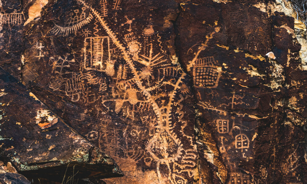
The Main Wall of Ancient Rock Carvings
The ‘Newspaper Rock’ at Parowan Gap is roughly about 200 square feet and contains more than 90 different carved pictures. These carvings show bighorn sheep, human figures, patterns, and symbols that go half an inch deep into the rock.
Different Native American groups, including the Fremont people and ancient Puebloans, added their own carvings to this wall over hundreds of years.

The Gap’s Natural Wind System
The shape of Parowan Gap creates a natural wind tunnel where winds travel fast in the narrowest parts. The passage cuts through cliffs that rise 200 feet high, funneling air through the gap. The temperature on each side of the gap can differ, which causes steady winds throughout the year.

Parowan Gap’s Water-Erosion History
The gap itself was carved by an ancient stream, possibly part of the Parowan Creek, which began eroding the landscape long before the Red Hills formed.
Today, you can see evidence of this ancient water flow in the smooth, curved walls and water-worn channels that line the gap. However, the current stream that runs through the gap is much smaller and only appears during rare flood events.

The Gap’s Rock Layer Timeline
You can see red sandstone layers that got their color from iron during the Jurassic period, while black basalt layers show times when volcanoes were active during the Tertiary period. These layers help scientists understand how the area’s landscape and climate changed over time.

Plants and Animals That Live in the Gap
Although Parowan Gap may appear barren, it is actually home to a variety of native plants, thanks to its sheltered location and unique wind patterns that help rare species thrive. The gap’s dry environment supports vegetation such as spearmint, Brigham tea, sagebrush, rabbitbrush, and pinyon.
In addition to plant life, Parowan Gap is also a haven for wildlife. Golden eagles and peregrine falcons nest in the high cliffs, while desert bighorn sheep can occasionally be spotted visiting the area.

The Gap’s History as a Trade Path
For years, different groups of people used Parowan Gap as a trading route. Archaeologists have found items like seashells from the Pacific Coast and obsidian tools from the Great Plains. The natural passage through the mountains creates an 8-mile corridor that was perfect for traders to travel through.

How Sound Travels in the Gap
The curved walls of the gap are angled which makes sound bounce in specific patterns. If you stand in certain spots, your voice will echo from several directions at once.
The post Utah Pioneers Traveled Through This Mountain Pass Covered in Ancient Petroglyphs appeared first on When In Your State.