


![Tyson Foods Plant [Photo: Food Manufacturing]](https://southarkansassun.com/wp-content/uploads/2023/08/iStock_1185520857__1_.5e441daa51cca-600x337.jpg)


![Silverado Senior Living Management Inc. [Photo: Los Angeles Times]](https://southarkansassun.com/wp-content/uploads/2023/10/download-6-4-600x337.jpg)

![China's Wuhan Institute of Virology [Photo: Nature]](https://southarkansassun.com/wp-content/uploads/2023/09/d41586-021-01529-3_19239608-600x337.jpg)


Mini Guide to a Big Sur Road Trip
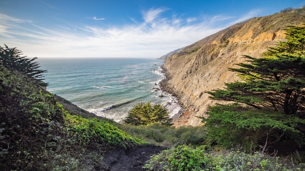
Big Sur’s coastline stretches 90 miles between Carmel and San Simeon, offering some of California’s most beautiful views. Along this famous section of Highway 1, you’ll find secluded beaches, towering redwoods, and dramatic cliffs that drop straight into the ocean.
This guide will show you the best places to stop, from famous bridges to quiet coves where you can escape the crowds. Pack comfortable shoes for hiking and don’t forget your camera – you’ll want to capture every moment of this incredible journey.

The Wildlife Haven of Point Lobos
Point Lobos State Reserve sits just south of Carmel, where several hiking trails wind through cypress trees and along rocky cliffs. Harbor seals rest on the rocks while sea otters float in beds of kelp, and you might spot gray whales passing by during their migration season.
The Cypress Grove Trail gives you the best views of the coast, and the water at China Cove glows a bright emerald green. Get there when the park opens to find parking easily, and stop by the Whaler’s Cabin Museum to learn about the local history. Bring binoculars if you want to watch the wildlife up close.

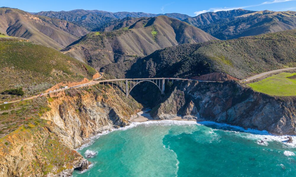
The Historic Bixby Creek Bridge
Bixby Creek Bridge stands 280 feet above the water, its concrete arch stretching across the canyon. Built in 1932, this bridge has become one of the most photographed spots along the coast.
Pull over at the turnout on the north side to get the classic view of both the bridge and coastline. The light is best during sunrise and sunset, but expect to share the view with other photographers.
For a different angle, take Old Coast Road to a less crowded viewpoint. On foggy mornings, clouds wrap around the bridge’s supports, creating a mysterious scene.

The Secret Shores of Garrapata State Park
Many people drive past Garrapata State Park without stopping, but those who know better find two miles of beautiful, quiet beach. Inside the park, trails lead through canyons where wildflowers bloom in spring, and the Soberanes Point trail offers peaceful ocean views.
You can often see whales and dolphins from the park’s overlooks. The trails here are less crowded than at other parks, making it perfect for a quiet walk along the coast. The beach stretches wide and long, giving you plenty of space to explore the shoreline.
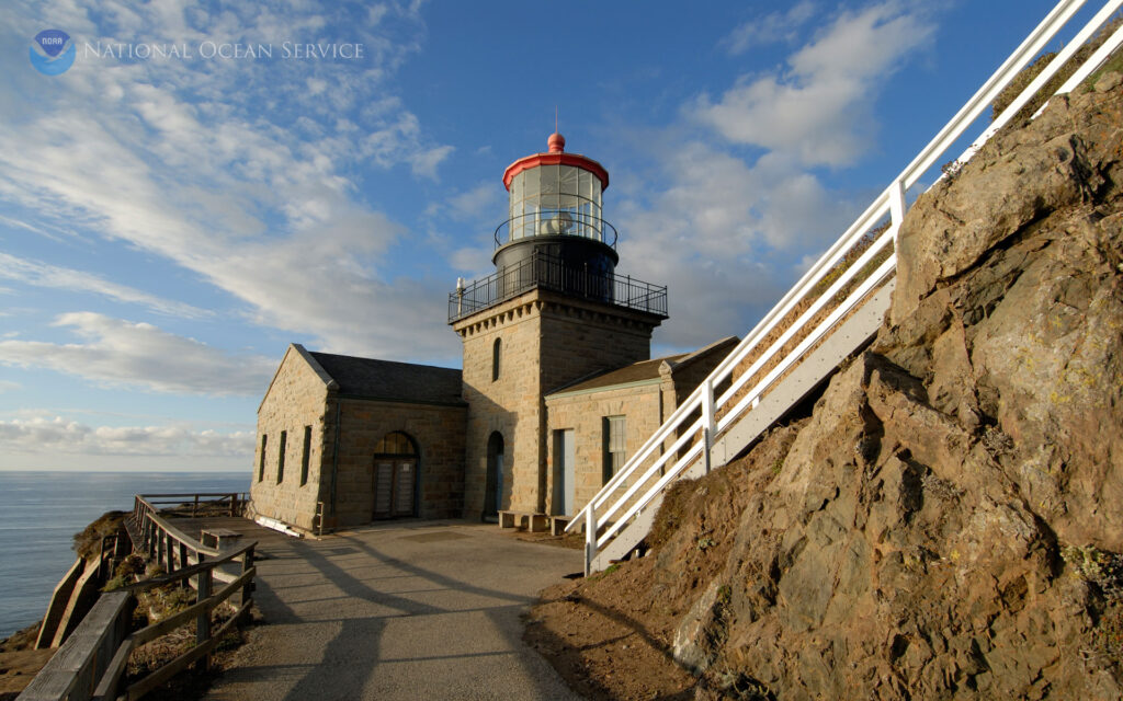
The Dramatic Point Sur Light Station
Point Sur Lighthouse sits on top of a massive volcanic rock that rises above the ocean. Built in 1889, the lighthouse still warns ships away from the dangerous coast. Local volunteers lead tours through the buildings, sharing stories about the lighthouse keepers and the ships that passed by.
You need to book your tour ahead of time, but the climb to the top rewards you with views that stretch for miles along the coast. The lighthouse looks particularly striking when storm clouds gather over the ocean.

The Natural Wonders at McWay Falls
McWay Falls flows right onto a beach in Julia Pfeiffer Burns State Park, dropping 80 feet from the cliff above. Though you can’t walk down to the beach, the viewing trail gives you perfect spots to take photos.
The short walk to see the falls is easy for most people, and the path is well-maintained. Visit in the evening when the setting sun turns the water golden. The falls flow all year, making this a reliable stop in any season.

The Purple Sands of Pfeiffer Beach
Pfeiffer Beach stands out for its unusual purple sand and large rock formations. The beach’s famous Keyhole Rock creates a window that frames the sunset perfectly during winter months.
Finding the beach takes some effort – the turnoff from Highway 1 isn’t marked – but the unique scenery makes it worth the search. Even on sunny days, bring a jacket because the wind can be strong. The waves here can be rough, but the beach is perfect for walking and taking photos.

The Diverse Landscapes of Andrew Molera State Park
Andrew Molera is Big Sur’s largest state park, where meadows roll down to meet secluded beaches. The Beach Trail takes you through changing landscapes before reaching a shore dotted with driftwood and bordered by cliffs.
California condors often soar overhead, their massive wings catching the coastal winds. During summer, you can cool off in the calm pools of the Big Sur River. The trails here range from easy walks to challenging hikes, giving visitors of all skill levels a chance to explore.

The Ancient Redwoods of Pfeiffer Big Sur
Pfeiffer Big Sur State Park shelters some of the region’s oldest and tallest redwood trees. The popular Pfeiffer Falls Trail leads through these giants to a 60-foot waterfall that flows most strongly after winter rains.
Camping here puts you right beside the Big Sur River, where the sound of flowing water fills the forest. For those seeking a challenge, the Valley View trail climbs through the woods to an overlook of the Santa Lucia Mountains.
The park feels most peaceful in early morning when fog drifts through the redwood canopy.

The Historic Kilns of Limekiln State Park
Limekiln State Park preserves four massive lime kilns from the 1880s, when they were used to process limestone. Three short trails branch out from the parking area, each offering a different experience of the park.
The Waterfall Trail leads to a 100-foot cascade, while the Hare Creek Trail follows a stream through the redwoods. The Limekiln Trail takes you to the old kilns themselves, where you can see how they were built into the hillside. Each trail is less than a mile long but packed with interesting sights.

The Long Stretch of Sand Dollar Beach
Sand Dollar Beach curves along the coast in a perfect crescent, making it Big Sur’s longest accessible beach. Large rocks frame the beach at both ends, creating dramatic backdrops for photos and protecting the shore from strong winds.
A sturdy staircase leads down to the sand, where you might find the flat, round fossils that give the beach its name. Surfers come here for the reliable waves, while beachcombers search the sand at low tide. The parking lot has restrooms and picnic tables, making this a good spot for a longer stay.

The Peaceful Waters of Willow Creek
Willow Creek offers a quiet place to fish, picnic, or simply watch the waves. The beach here is usually empty, even during busy summer months.
In spring, the surrounding hills fill with purple and yellow wildflowers. This spot makes an excellent break from driving, with plenty of space to spread out a blanket and relax.
The creek provides fresh water to a small lagoon where birds often gather. The area has some of the coast’s best fishing spots, especially during salmon season.

The Hidden Falls at Salmon Creek
A short but steep trail leads you to Salmon Creek Falls, where water drops 120 feet over granite cliffs. The falls are fullest in spring when winter rains and melting snow feed the creek.
Morning light illuminates the falls best, and fewer people visit at this time. The path can be slippery after rain, but wooden railings help with the climb. Dense forest surrounds the trail, keeping it cool even on warm days.

The Wildlife Spectacle at Piedras Blancas
At Piedras Blancas, thousands of elephant seals gather on the beach throughout the year. These massive animals can weigh up to 5,000 pounds, and watching them is both fascinating and free.
December through March brings the most activity, when males battle for territory and mothers care for their pups. Boardwalks along the beach give you clear views while keeping a safe distance from the seals. Helpful signs explain the seals’ behavior and life cycle.
The Final Vista at Ragged Point
Ragged Point marks the southern end of Big Sur, where cliffs rise 400 feet above the Pacific. A viewing platform lets you look back at the coastline you’ve traveled, while the inn offers a comfortable place to rest.
The post The 14 Loveliest Stops on a Big Sur Road Trip appeared first on When In Your State.