


![Tyson Foods Plant [Photo: Food Manufacturing]](https://southarkansassun.com/wp-content/uploads/2023/08/iStock_1185520857__1_.5e441daa51cca-600x337.jpg)


![Silverado Senior Living Management Inc. [Photo: Los Angeles Times]](https://southarkansassun.com/wp-content/uploads/2023/10/download-6-4-600x337.jpg)

![China's Wuhan Institute of Virology [Photo: Nature]](https://southarkansassun.com/wp-content/uploads/2023/09/d41586-021-01529-3_19239608-600x337.jpg)


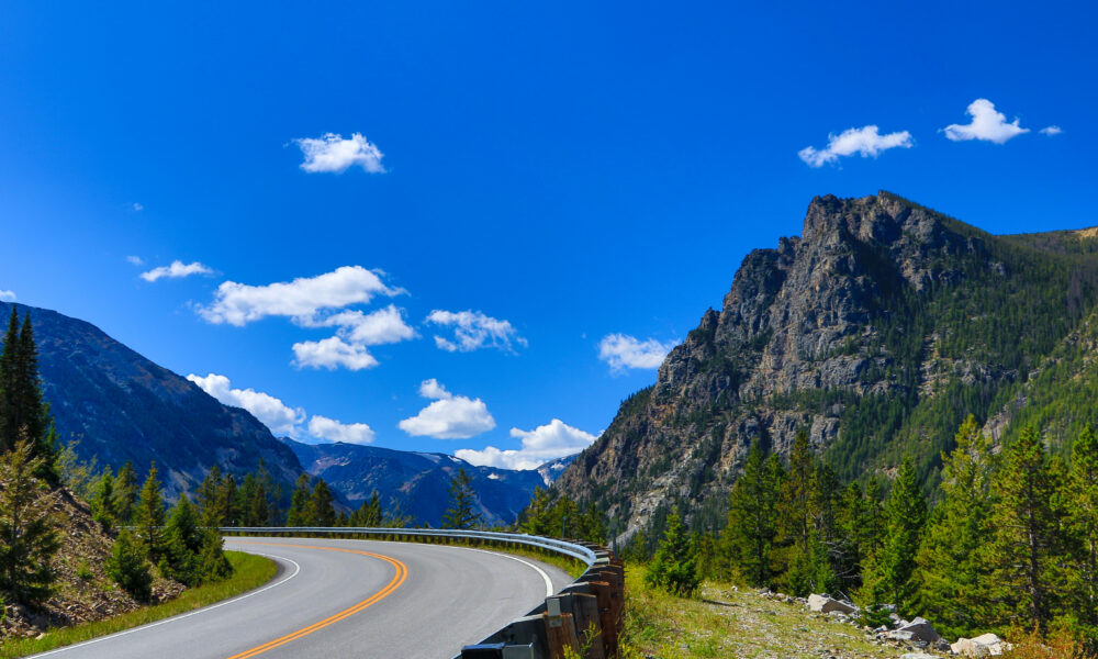

What to Expect from the Beartooth Highway
Beartooth Highway belongs on any road trip bucket list. It takes you through some of America’s most stunning mountain landscapes, climbing almost 11,000 feet into the sky.
It’s also one of the most dangerous and only open from the Friday of Memorial Day weekend through mid-October.
Here’s exactly what to expect, from the white-knuckle switchbacks to the spots where you’ll need to catch your breath (both from the views and the altitude).

About Those Scary Drops
There’s no guardrails for about 20 miles of this drive. While you’re driving, you’ll see drops of over 1,000 feet, especially near Beartooth Pass. The scariest part is around Rock Creek Vista Point. When you’re driving, it feels like you’re right on the edge.
They left the guardrails off on purpose, by the way. Partly so they can clear snow in winter, and partly so drivers can see better. Fortunately, they haven’t had many deadly accidents because of the missing guardrails. Most problems happen when drivers aren’t careful or when the weather’s bad.

The Turns Are Pretty Intense
You’ll deal with more than 30 really tight turns. Some are so tight you only have 100 feet to make the turn. Your car will climb 5,500 feet, and some parts are really steep, going up to 10%.
If you’re driving an RV or pulling a trailer, be super careful. You might tip over if you’re not. Some turns are so sharp you’ll need to slow down to 15 mph. When you’re driving these turns, you’ll want to use a lower gear and watch your speed carefully.

The Weather Changes Really Fast While You’re Driving
The Beartooth region sits where multiple weather patterns meet. You’ve got cold Arctic air from the north, warm Pacific air from the west, and continental air masses from the east. The highway also climbs from 5,200 to 10,947 feet in a relatively short distance, so the weather is incredibly unpredictable.
Always expect the worst. Summer snowstorms, fog, and thunderstorms can reduce visibility to near-zero on Beartooth Highway. If you’re planning to drive it, subscribe to weather updates from the National Park Service and the Montana Department of Transportation website.

The Highway is Avalanche Territory
Beartooth Highway is always closed during winter, and avalanches are one of the biggest reasons. Sometimes the snow plows have to stop working because it’s too dangerous.
But since the weather here can turn on a dime and summer snowstorms happen sometimes, always stay on alert. New snow, rain, warm weather, or wind can start an avalanche while you’re on the road.

The Road Is Really Narrow
Some parts where you’ll drive are only 14-20 feet wide, and that’s for both lanes. It also lacks proper shoulders in many sections. No extra space on the sides either.
You’ll need to be careful when cars come the other way, especially in those tight spots. The risk of sideswipe accidents is really high here, especially when larger vehicles like RVs or trucks are involved.

The High Altitude Affects Your Driving
While you’re driving, you’ll go up to 11,000 feet. The air’s pretty thin up there. Once you get above 8,200 feet, you might start feeling weird. Your head might hurt, you might feel sick to your stomach, get dizzy, feel really tired, or have trouble concentrating.
That’s normal, so don’t panic. If you start feeling bad, find a safe place to pull over and rest.

The View Changes Can Be Crazy
As you drive up past 9,000 feet, the road takes you through what looks like the Arctic depending on when you hit the highway.
In summer, you’ll see purple and red wildflowers (lupines and Indian paintbrushes).

Spectacular Mountain Views
The mountain views alone make Beartooth Highway worth it. While driving, you’ll see more than 20 mountains over 12,000 feet high.
Keep your eyes on the road, though, since there are several designated spots to pull over safely and look around.
The biggest mountain you’ll see is Granite Peak (12,799 feet). They built special pullouts like Rock Creek Vista Point where you can safely stop and take pictures.

You’ll Pass By Some of Montana’s Best Lakes
Beartooth Highway is dotted by numerous alpine lakes like Long Lake, Little Bear Lake, and Island Lake.
If you have time, we definitely recommend boating, fishing, and camping on any of them. You can also go on a moderate hike with fantastic forest views at Crazy Creek Falls.

Beartooth Highway is an Official “All-American Road”
The Beartooth Highway earned All-American Road status in 2002. It combines some of the best parts of a road trip, like gorgeous scenery, recreational access, and stops like the Top of the World Store and historic mining towns.
The road also passes through ancient geological formations like 500-million-year-old rock formations.

Gets You All the Way to Yellowstone
The road ends at Yellowstone’s Northeast Entrance. This entrance usually isn’t crowded, which makes for easier driving.
While you’re driving through Lamar Valley, watch out for animals on the road – they show up a lot here. You might see wolves, bison, or bears, so drive slowly and be ready to stop. P
ark rangers use this road all the time, so follow their lead if you see them.
The post Your No-BS Guide to “Highway to The Sky,” Montana’s Most Dangerous Road appeared first on When In Your State.