


![Tyson Foods Plant [Photo: Food Manufacturing]](https://southarkansassun.com/wp-content/uploads/2023/08/iStock_1185520857__1_.5e441daa51cca-600x337.jpg)


![Silverado Senior Living Management Inc. [Photo: Los Angeles Times]](https://southarkansassun.com/wp-content/uploads/2023/10/download-6-4-600x337.jpg)

![China's Wuhan Institute of Virology [Photo: Nature]](https://southarkansassun.com/wp-content/uploads/2023/09/d41586-021-01529-3_19239608-600x337.jpg)


Hana Highway Welcomes The Brave
The Road to Hana winds through Maui like a ribbon, packing adventure into every mile.
Though it’s just 52 miles from Kahului, you’ll need two to four hours to navigate its narrow bridges and hairpin turns – but the island views make every minute worth it.
Here’s why.

The Highway’s 600+ Curves Stretch 64 Miles
The Hana Highway snakes along for 64.4 miles, combining Hawaii Routes 36 and 360 to link Kahului with Hana in east Maui.
Though Hana sits only 52 miles from Kahului, the drive takes about 2.5 hours without stops. You’ll twist through roughly 620 curves on Route 360 past Kahului, most cutting through thick rainforest.
The road threads through Hawaii’s most remote communities before opening up to Hana’s pristine landscapes.

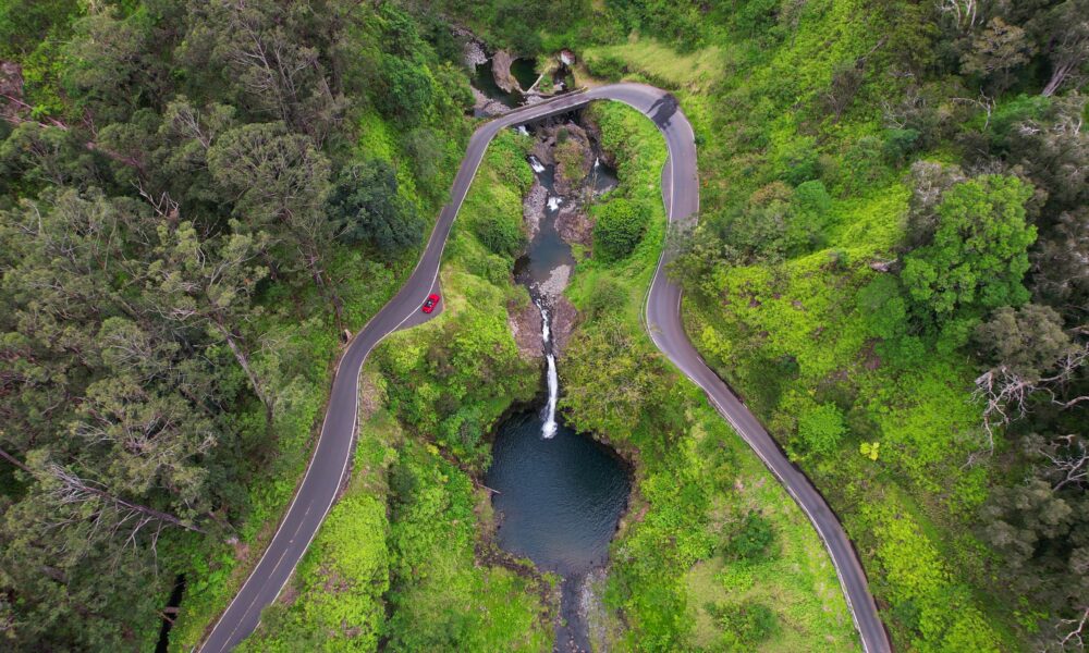
59 Bridges, Most Just One Lane Wide
Part of what makes this drive so challenging is its 59 bridges, 46 of them single-lane crossings where cars take turns, each with its Hawaiian name.
These concrete and steel spans date to 1910, and all but one still carry traffic. The speed drops to 10-15 mph in spots, perfect for taking in views around each bend.
Most bridges cross streams feeding waterfalls and swimming holes, creating photo opportunities framed by thick greenery.

Sharing Space with Oncoming Traffic
The highway often squeezes cars together, especially where two can’t pass side by side.
Nothing gets your heart racing quite like sharing the road with a truck while your tire edges toward the drop-off.
Though well-maintained, the road demands caution. Tight spots, hairpin turns, and cliff edges make for white-knuckle driving.
Blind turns, speedy bikes, and occasional construction also create hazards, especially when others don’t give enough passing room.

Morning Fog Challenges
Morning fog often shrouds the higher mountain passes. Half of Hawaii sits above 2,000 feet, with 10% reaching past 7,000 feet.
Mountain slopes and peaks in the cloud belt regularly meet fog or cloud mists. Scientists say this “fog drip” gives vegetation and soil nearly as much water as rain does.
For drivers, especially those new to the route, this means reduced visibility. Many wait until mid-morning or noon when conditions improve.

Rock Falls Pose Real Risks
The cliffs flanking the highway sometimes shed rocks and debris, especially after heavy rains or earthquakes.
In May 2023, officials closed a mile near Alelele Point due to rockfall danger. Later that year, Tropical Storm Olivia’s rains shut down the whole highway.
While the Highway Department watches trouble spots, smart drivers plan for possible detours or delays.
Tools like the GyPSy Guide app help navigate tricky sections safely.

The Wild "Back Road"
Past Hana, the road turns adventurous with unpaved lava field routes.
Locals call this stretch “The Beyond” or “the backside of Haleakala,” offering raw glimpses of Maui’s volcanic past.
After Kaupo, look for the Pokowai Sea Arch, carved where Haleakala’s lava met the Pacific. Then comes the massive Manawainui Gulch.
The road alternates between potholes and pavement, passing Hawaiian ruins and endless miles of untamed country.

Watch Those Blind Corners
The road’s design creates super tricky blind corners due to poor surfaces, few guardrails, heavy tourist traffic, and deadly drop-offs.

Stunning Views Along the Way
The route passes natural wonders like Twin Falls, Honomanu Bay, and the Hana Lava Tube. Paia Town offers the last services before Hana.
The Garden of Eden Arboretum showcases lush gardens, while Wai’anapanapa State Park features a black pebble beach, ocean cave, lava arch, and coastal trails.
Rainbow eucalyptus trees pop with color at miles 7 and 16, with another view at the Halfway to Hana stand (mile 17).

Red Sand Beach Near Hana
Near peaceful Hana town, find Kaihalulu Beach’s volcanic red sand.
“Kaihalulu” means “roaring sea” in Hawaiian, fitting for its rough waters. The beach consists of red cinders from an unstable volcanic cone crumbling seaward.

A Waterfall Paradise
The highway showcases over 15 waterfalls in 54 miles, like the Upper Waikani Falls (Three Bears) that drops 70 feet in three parallel streams.
Waikamoi Falls varies from dry to powerful depending on rain. Lower Puohokamoa Falls lies past mile 10, visible from the Garden of Eden.
Locals love Ching’s Pond (Blue Sapphire Pools) past mile 16.

Black Sand Beaches
The Hana Highway also passes through spots like Pa’iloa Beach.
Located in Waianapanapa State Park, the beach got its black sand from Haleakala’s lava meeting ocean water. The iron-rich volcanic material creates deep black grains that shelter native species.
One’uli Beach near Wailea offers snorkeling at its nearshore reef (known to be home to green sea turtles).

Sacred Grounds Along the Way
The route passes ancient Hawaiian burial grounds.
Ka’uiki Hill in Hana Bay holds Queen Ka’ahumanu’s birth cave from 1768. Find Charles Lindbergh’s grave at Palapala Ho’omau Church.
Visit these sacred sites respectfully. Some require permission to access them.
The post America’s Most Beautiful Highway Has a Nerve-Wracking 600 Curves, 59 Bridges, and an Unpaved Lava Field appeared first on When In Your State.