


![Tyson Foods Plant [Photo: Food Manufacturing]](https://southarkansassun.com/wp-content/uploads/2023/08/iStock_1185520857__1_.5e441daa51cca-600x337.jpg)


![Silverado Senior Living Management Inc. [Photo: Los Angeles Times]](https://southarkansassun.com/wp-content/uploads/2023/10/download-6-4-600x337.jpg)

![China's Wuhan Institute of Virology [Photo: Nature]](https://southarkansassun.com/wp-content/uploads/2023/09/d41586-021-01529-3_19239608-600x337.jpg)


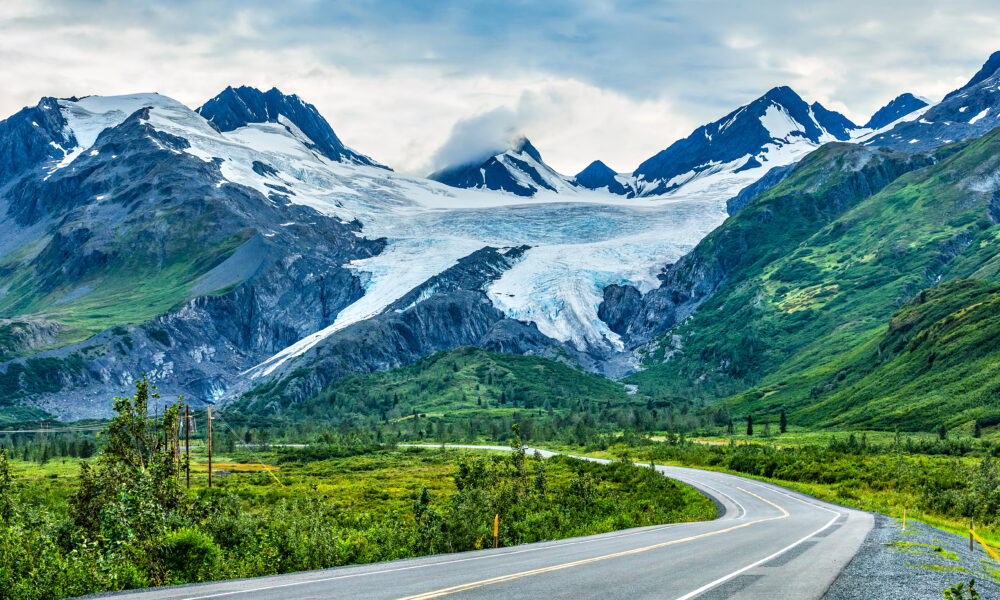

Richardson Highway, Alaska
The Richardson Highway wrote Alaska’s roadmap, literally. Starting as a gold rush trail in 1898, this 366-mile route now connects Fairbanks to Valdez through some of the state’s most remote territory.
Between its endpoints lie massive glaciers, 2,800-foot mountain passes, and wildlife corridors that remind you this is still frontier country.

Gold Rush Travelers Preferred Winter Dog Sleds
Before the Richardson became a proper highway, it was just a wilderness trail used by desperate gold hunters.
They actually found winter travel easier when dog sleds could zip over frozen ground instead of slogging through summer’s deep mud. In 1904, Congress finally funded road building throughout Alaska, and President Theodore Roosevelt put Major Wilds Richardson in charge of the project.
A huge milestone came in July 1913 when Robert Sheldon and three friends drove from Fairbanks to Valdez in a Ford Model T with a “Valdez or Bust” banner, finishing the journey in 59 hours.
You can still visit Rika’s Roadhouse from 1910, now preserved in Big Delta State Historical Park, to see how early travelers rested on this tough route.

The Massive 2014 Avalanche That Created a Lake
One of the wildest things to happen on this highway went down on January 24, 2014. Nearly a foot of rain and unusually warm temps triggered massive avalanches near Thompson Pass.
People called it the “damalanche” because the avalanches not only blocked the road but also dammed up the Lowe River, creating a lake 30 feet deep and half a mile long.
This natural disaster completely cut off Valdez from road access for 12 days. Road crews had to wait a full week for the water to go down before they could start clearing 200,000 cubic yards of snow, working around the clock for five days with help from all over the state.
Surprisingly, the highway had minimal damage once all the snow was gone – just some busted guardrails.

800 Mile Long Oil Pipeline Follows Your Drive
The Trans-Alaska Pipeline runs alongside the Richardson Highway for much of your drive, giving you plenty of chances to check out this engineering marvel.
Built between 1973 and 1977, this pipeline carries oil 800 miles from Prudhoe Bay all the way to Valdez, crossing three mountain ranges and hundreds of rivers.
Look for the special viewpoint at milepost 243.5 with informative signs about the pipeline and Alaska wildlife. Another cool spot to see it is just after the unique bridge with the pipeline bridge next to it before you get to Delta Junction.

Active Volcanoes Are Visible From The Road
As you drive the Richardson, you’ll see the amazing Wrangell Mountain Range with its volcanic peaks creating a dramatic backdrop.
Mt. Wrangell stands 14,163 feet tall and is actually a semi-active volcano you can spot from certain points along your route.
The whole Wrangell Range covers over 5,000 square miles with 12 peaks taller than 10,000 feet. Don’t miss Rainbow Ridge, a 6,000-foot high ridge named for its colorful slopes – the reds and greens come from volcanic rock while yellows and pastels are from siltstone.

Thompson Pass Gets 45 Feet of Snow Yearly
If you’re driving in winter, prepare for Thompson Pass – the snowiest place in Alaska with an average of 551.5 inches (that’s over 45 feet) of snow every year. This section of highway stayed closed in winter until the mid-1950s when regular snow clearing finally began.
Even today, heavy snow and strong winds can shut down this stretch for days, with avalanches hitting several times each winter. The road maintenance station at Thompson Pass even has its own avalanche expert to help keep travelers safe.

Drive Carefully Through Narrow Keystone Canyon
One of your biggest driving challenges will be Keystone Canyon with its tight curves and steep rocky walls. The Lowe River carved this narrow gorge, creating a passage that demands careful driving, especially in bad weather.
Despite the driving challenges, you’ll see spectacular waterfalls including Bridal Veil Falls and Horsetail Falls cascading down the steep canyon walls.
Near Bridal Veil Falls, you can hike the Valdez Goat Trail, a restored section of the first glacier-free route from Valdez to the interior. In summer, the canyon becomes popular for hiking and rafting adventures.

Plan Your Gas Stops Between Towns Carefully
Though the Richardson is fully paved and well-maintained, services along the way are much farther apart than what you’re used to in the Lower 48. Plan your fuel stops carefully, with places like Meier’s Lake Roadhouse serving as crucial fill-up points in otherwise empty stretches.
You’ll find major services in Fairbanks, North Pole, Delta Junction, Glennallen, and Valdez, but there can be long distances between these towns. Gas stations and food spots are usually found in the same places where lodging is available.
Always fill your tank when passing through actual towns and don’t count on gas being available at remote roadhouses. Cell coverage gets spotty in many areas too, so don’t rely on having constant phone service.

Walk Right Up To Massive Worthington Glacier
Worthington Glacier ranks as one of the most visited stops on the Richardson and is among the few glaciers in the world you can drive right up to. Located near Thompson Pass, this glacier lets you see a massive river of ice up close without needing a boat or plane to get there.
The Worthington Glacier State Recreation Area has trails leading near the glacier’s face, with best viewing in mid-summer when snow has melted away from the hiking paths. You’ll find several pull-offs over a couple of miles to view this amazing sight.

Christmas Town Exists Year Round In North Pole
One of the more surprising stops along your drive is the Santa Claus House in North Pole, Alaska, just 15 miles from Fairbanks. This unique attraction celebrates Christmas all year round in what used to be a frontier general store and post office.
The entire town of North Pole goes all-in on its Christmas theme with street names like Santa Claus Lane and St. Nicholas Drive, plus light poles painted like giant candy canes. You can also check out the Antler Academy of Flying & Reindeer Games and the KJNP radio/TV complex with its sod roof.

Catch Huge Salmon in Copper Center
The Copper River Valley along the Richardson offers some of the best king salmon fishing anywhere in Alaska, with salmon averaging a massive 40 pounds each.
The Klutina and Gulkana Rivers are known as some of the state’s top fishing spots. You can book float trips with companies like AK Fish Charters to try your luck with salmon and other fish species in these rich waters.
After fishing, enjoy hearty meals or sourdough pancakes made from genuine 100-year-old sourdough starter at local restaurants. The highway runs right along the Copper River, giving easy access to world-class salmon fishing.

Visit America’s Largest National Park From Mile 83
At mile 83 of your drive, you can turn onto the Edgerton Highway leading to Chitina and the edge of the massive Wrangell-St. Elias National Park. Though you can drive from Chitina to Kennicott and McCarthy, many people recommend flying instead because the road gets pretty rough.
Kennicott was built solely to support the Kennecott Copper Mine (different spelling) which ran from 1911-1938, and today you can tour the abandoned mine buildings in this fascinating ghost town.
The park’s Wrangell-St. Elias Mountains have the highest concentration of peaks over 16,000 feet in North America.
Stop at the visitor center near Copper Center to plan adventures into America’s largest national park. From certain viewpoints along your drive, you can see the spectacular Wrangell Range more than 50 miles away.

See Alpine Tundra Without Hiking at Isabel Pass
Historically, Isabel Pass was a crucial link in Richardson’s original three-section division of the trail, connecting Copper Center to the route toward Fairbanks. The road gradually climbs toward the pass, and higher areas often keep snow even during summer.
Today, Isabel Pass gives you a rare chance to experience alpine tundra without having to hike for hours. At 3,280 feet, it’s the highest point on the Richardson Highway.

Check Out Hundreds of Free Roaming Buffalo
Technically, the Alaska Highway ends here at Delta Junction, and the road continues to Fairbanks as the Richardson Highway. Delta Junction sits at mile 266 of the Richardson and was once called Buffalo Center because it was picked for the government’s buffalo import program.
Today, there’s a huge 90,000-acre area with over 500 free-roaming buffalo nearby. Inside the visitor center, you’ll find homemade Alaskan crafts and a large taxidermy bison greeting you at the door.

Driving Alaska’s Richardson Highway
The Richardson Highway links Valdez (mile 0) with Fairbanks (mile 364-366). The entire route is paved and open year-round, though winter weather can cause temporary closures.
The road is generally in good shape but still has bumpy sections and rough patches, so drive carefully. A one-way trip takes about 6-8 hours without stops, but you should allow extra time to enjoy the road.
The post Alaska’s Oldest Road Winds Past Glaciers, Active Volcanoes & North America’s Largest Oil Pipeline appeared first on When In Your State.