


![Tyson Foods Plant [Photo: Food Manufacturing]](https://southarkansassun.com/wp-content/uploads/2023/08/iStock_1185520857__1_.5e441daa51cca-600x337.jpg)


![Silverado Senior Living Management Inc. [Photo: Los Angeles Times]](https://southarkansassun.com/wp-content/uploads/2023/10/download-6-4-600x337.jpg)

![China's Wuhan Institute of Virology [Photo: Nature]](https://southarkansassun.com/wp-content/uploads/2023/09/d41586-021-01529-3_19239608-600x337.jpg)


Cascade Loop, Washington
Often called a ‘440-mile love letter to Washington,” the Cascade Loop combines three scenic byways: Stevens Pass Greenway, North Cascades Highway, and Whidbey Scenic Isle Way, covering nine distinct regions.
The landscape changes dramatically every few hours. You’ll go from dense forests to open prairies, pass farms growing berries and hops, then climb to wilderness areas with mountain goats on rocky slopes.
If you only have time for one road trip this year, make it this one. Here are some of our favorite stops along the Cascade Loop.

Diablo Lake
Nothing prepares you for Diablo Lake’s striking turquoise water as you drive through the North Cascades. This unusual color comes from ‘glacial flour’—rock particles ground by glaciers, washed into the lake where they remain suspended and reflect light. It’s most vibrant during summer glacier melt.
Stop at Diablo Lake Overlook to see Colonial Mountain and Davis Peak rising from the shoreline. The lake formed when Seattle City Light built Diablo Dam in 1930, raising the water level 165 feet.
Boat tours operate from June to September, letting you experience this geological wonder up close as you continue your Cascade Loop journey.

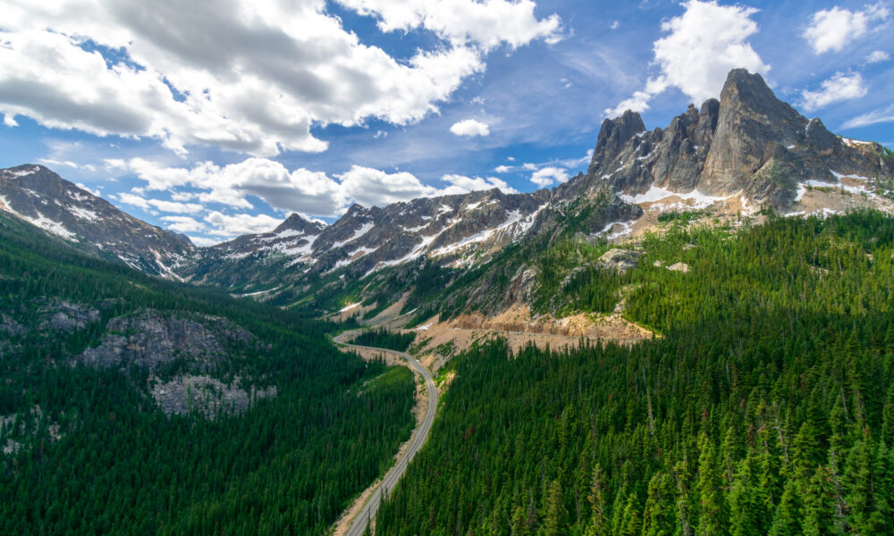
Liberty Bell Mountain
Towering above Washington Pass, the highest point on your drive, stands Liberty Bell Mountain. It looks like Philadelphia’s Liberty Bell, complete with a crack, hence the name.
This 7,720-foot peak has a golden glow from metamorphic rock formed 65 million years ago. Rock climbers tackle its 2,000-foot east face, first conquered by Jim and Lou Whittaker in 1946.
Stop at Washington Pass Overlook where a paved trail offers views of the mountain and Highway 20 snaking 700 feet below.

The Jack Kerouac Connection
Few travelers know about the literary connection hiding in the North Cascades section of the loop. In 1956, Jack Kerouac spent 63 days as a fire lookout on Desolation Peak, later writing ‘Desolation Angels’ based on this experience.
Kerouac arrived with just one suitcase of books, writing supplies, and port wine when a helicopter dropped him at the remote fire tower. His tiny 12×12-foot cabin still stands today. You can see Desolation Peak from Ross Lake Overlook as you drive Highway 20.

Historic Leavenworth
Midway through your trip is Leavenworth, Washington’s Bavarian village. This fairytale town welcomes roadtrippers with Alpine architecture, German restaurants, and half a million Christmas lights in winter.
The area also offers 800+ miles of hiking trails, including the famous Enchantments, while the Wenatchee River provides excellent rafting from May through July.

Lake Chelan
Stretching like a 55-mile blue finger cutting into the mountains, Lake Chelan appears as you travel the eastern route.
This lake creates perfect conditions for recreation and winemaking, with resorts and over 30 wineries along its shores taking advantage of rich soil and abundant sunshine.
At 1,486 feet deep, it’s America’s third deepest lake, with its bottom 386 feet below sea level. The Lady of the Lake ferry takes you to Stehekin, a remote community with no road access and fewer than 100 year-round residents.

Methow Valley
Entering the northeast section brings you to the Methow Valley, which feels like driving into a Western movie.
This authentic western landscape features North America’s largest network of cross-country ski trails, spanning 120+ miles. Summer transforms these into routes for hiking, biking, and horseback riding.
Named after the Native American tribe who gathered food here for millennia, the valley includes Winthrop, a town embracing its 1890s frontier heritage with wooden boardwalks and western buildings.

Skagit Valley
Mountains give way to vast farmland as you enter Skagit Valley on your journey. This agricultural wonderland grows diverse crops but becomes world-famous during spring when La Conner and Mount Vernon host spectacular Daffodil and Tulip Festivals.
The valley’s rich soil comes from volcanic material deposited by the Skagit River over thousands of years. April drives reward you with millions of tulips creating colorful patterns across fields. This area produces 95% of America’s beet, spinach, and cabbage seeds.
Winter brings the largest concentration of bald eagles in the lower 48 states, feeding on salmon along the upper Skagit River.

Deception Pass
Deception Pass State Park surrounds this crossing with old-growth forests, wildlife habitats, sand dunes, and homes for 174 bird species.
The 1935 bridge places you 180 feet above powerful tidal currents moving at 8 knots. Captain George Vancouver named it ‘Deception’ in 1792 after discovering what he thought was mainland was actually Whidbey Island.
Walk the bridge’s pedestrian path for views of swirling waters where the Strait of Juan de Fuca meets Puget Sound. Nearby trails lead to beaches where you might spot seals, porpoises, and occasionally orcas.

Whidbey Island
Continuing down Whidbey Island offers a complete contrast to earlier mountain sections. This green island features artists’ communities, historic towns, and rocky beaches. Though 57 miles long, it’s only 1.5 to 10 miles wide, making it Puget Sound’s largest island.
Driving south brings you through Coupeville, Washington’s second-oldest town, with over 100 pre-1910 buildings. You’ll pass Penn Cove, famous for mussels harvested since the 1970s. The island’s ‘rain shadow’ receives just 20-30 inches of rain annually, half of Seattle’s average.
From the southern end on clear days, Mount Rainier rises 14,411 feet in the distance.

Stevens Pass
Rolling hills transform into rugged peaks as you reach Stevens Pass. Following the Skykomish River past historic towns like Sultan and Skykomish, where anglers fish for steelhead and salmon, the highway climbs to 4,061 feet.
This ancient route became part of the Great Northern Railway in 1893. The 1910 Wellington Disaster occurred nearby when an avalanche killed 96 people on stranded trains.
Stevens Pass Ski Area receives 450 inches of snow yearly, creating dramatically different driving experiences by season. Watch for waterfalls visible from your car, including Deception Falls. The Pacific Crest Trail crosses directly at the pass.

Driving the Cascade Loop
The North Cascades Highway section (Highway 20) closes mid-November through early May due to snow and avalanche danger, making the complete loop impossible during winter.
Drive the full 440 miles between June and October when all roads are open. Start anywhere and go either direction. Most Seattle travelers begin in Everett or Mukilteo. Allow at least three days, though five to seven provides a better experience.
Fill up in Marblemount or Winthrop before crossing the North Cascades where services are limited. Download offline maps as cell service disappears in mountains. Pack layers for elevation changes from sea level to 5,400+ feet.
The post This Legendary Mountain Loop Passes Alpine Lakes, Tulip Valleys, and a Bavarian Village appeared first on When In Your State.