


![Tyson Foods Plant [Photo: Food Manufacturing]](https://southarkansassun.com/wp-content/uploads/2023/08/iStock_1185520857__1_.5e441daa51cca-600x337.jpg)


![Silverado Senior Living Management Inc. [Photo: Los Angeles Times]](https://southarkansassun.com/wp-content/uploads/2023/10/download-6-4-600x337.jpg)

![China's Wuhan Institute of Virology [Photo: Nature]](https://southarkansassun.com/wp-content/uploads/2023/09/d41586-021-01529-3_19239608-600x337.jpg)


Mount Evans Scenic Byway, Colorado
This road is a gorgeous drive through five different climate zones high up in the Rockies. On the way up, you’ll spot wildflowers, lichens, grasses, little furry marmots, and some really beautiful alpine lakes.
But before you get there, your car needs to climb 7,000 feet in just 28 miles. And that’s just one of the many challenges you’ll face on the highest paved road in America.

The Road Has No Guardrails for 14 Turns
Those last 5 miles after Summit Lake? They’ve got 14 crazy-tight turns with zero guardrails. Your passenger-side tires often sit just inches from massive drop-offs.
The views are stunning, but the road’s in rough shape with no safety barriers, so take it slow. Locals call the worst turn “Devil’s Elbow”, a blind 180-degree corner with a steep drop-off and crumbling edge.

Mountain Goats Will Climb on Your Car
There’s tons of mountain goats, and they’ve gotten way too comfortable around people. They’ll run toward crinkling food wrappers, come right up to people with food, stick their heads in cars, lick salt off vehicles, and even stand on top of cars.
This creates what locals call “goat traffic jams” – herds of goats surrounding your car, sometimes climbing on hoods and bumpers. Don’t honk or try to drive through them unless you want a hefty fine.

Your Brain and Car Both Run Poorly at 14,000 Feet
At 14,000 feet, both you and your car get way less oxygen than normal. You might notice slower reactions, feeling weirdly good, or seeing things a bit off. Your car loses about a third of its power up there. Automatic transmissions get confused between gears. Older cars with carburetors might not even make it to the top without adjustments.

Mile 9 Can Destroy Your Transmission
The steepest part at mile 9 has killed countless transmissions. The long 15% grade makes automatic transmissions heat up fast. Experienced drivers bring transmission temperature gauges and stop at Walter Pesman Trailhead when temperatures hit 220°F. They don’t allow vehicles over 30 feet long or RVs on this road, by the way.

Lightning Strikes Here 25,000 Times Per Year
This road gets hit by lightning more than almost anywhere in North America – over 25,000 strikes a year. Between 2 to 4 PM in summer, you might catch what locals call the “Peak Lightning Show.” The metal posts along the upper road act like giant lightning rods. During storms, you can see blue electrical sparks moving along the edge of the road.

The Best View Is Not at the Summit, Surprisingly
At Echo Lake around mile 3, there’s a hidden gravel road most tourists never notice. You need a vehicle with decent clearance, but it’s worth it.
This short quarter-mile side trip gives you an amazing 180-degree view of Chicago Lakes Basin that most visitors miss completely.
Even professional photographers think this view beats what you see at the summit.

You Can See 100 Miles on Clear Days
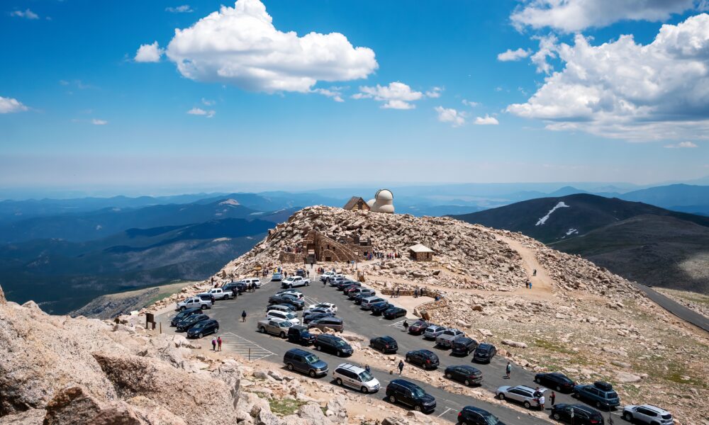
Once you’re at the top, there’s a short quarter-mile walk to the 14,264-foot summit.
The view is mind-blowing, one of the best in Colorado, letting you see from the Never Summer Range up north all the way to the Sangre de Cristo Mountains down south.
On clear mornings, you can see 100 miles across the Continental Divide. You’ll spot over 30 named peaks from up there. Sometimes rangers hold “peak-finding” sessions to help visitors identify all the distant mountains.

America’s Highest Restaurant Used to be Here
The summit has the stone remains of the Crest House, which was America’s highest commercial building until it burned down in 1979. The building used to have a restaurant where you could mail postcards from 14,130 feet.
Now, the observation deck built inside the ruins shelters you from the crazy-strong winds that often hit 70mph or more. The wind-worn ruins make for amazing photos as clouds flow through the stone arches.

A Piece of Alaska Sits 1500 Miles South
This is one of the few places where you can find arctic tundra this far south of the Arctic Circle. The Summit Lake parking area at mile 9 (12,840 feet) puts you next to America’s highest-named lake, surrounded by plants and soil that match what you’d find in northern Alaska. Scientists actually call this area a “100-acre island of Arctic Alaska” sitting 1,500 miles south of where it should be.

The Road Will Be Closed Until May 2026
IMPORTANT UPDATE: The road will be closed until May 2026.
- The upper part of Mount Blue Sky Scenic Byway will be closed all of 2025 for construction.
- Closure runs from September 3, 2024, through all of 2025.
- The closed area starts at the CDOT gate on Highway 5 and goes above Summit Lake.
- You can only reach the summit by hiking trails during this time.
- The road should reopen around Memorial Day weekend 2026, weather permitting.
When the road reopens in 2026, you’ll need timed-entry reservations from recreation.gov. To get there, take Exit 240 from I-70 in Idaho Springs, follow signs to Highway 103, drive south 14 miles, then turn onto Highway 5 past Echo Lake Lodge for another 14 miles to the summit.
There’s no cell service out here so get batteries and a satellite phone before leaving Idaho Springs or Bergen Park.
The post America’s Highest Paved Road Takes Drivers Above 14,000 Feet Where Even Trees Can’t Survive appeared first on When In Your State.