


![Tyson Foods Plant [Photo: Food Manufacturing]](https://southarkansassun.com/wp-content/uploads/2023/08/iStock_1185520857__1_.5e441daa51cca-600x337.jpg)


![Silverado Senior Living Management Inc. [Photo: Los Angeles Times]](https://southarkansassun.com/wp-content/uploads/2023/10/download-6-4-600x337.jpg)

![China's Wuhan Institute of Virology [Photo: Nature]](https://southarkansassun.com/wp-content/uploads/2023/09/d41586-021-01529-3_19239608-600x337.jpg)


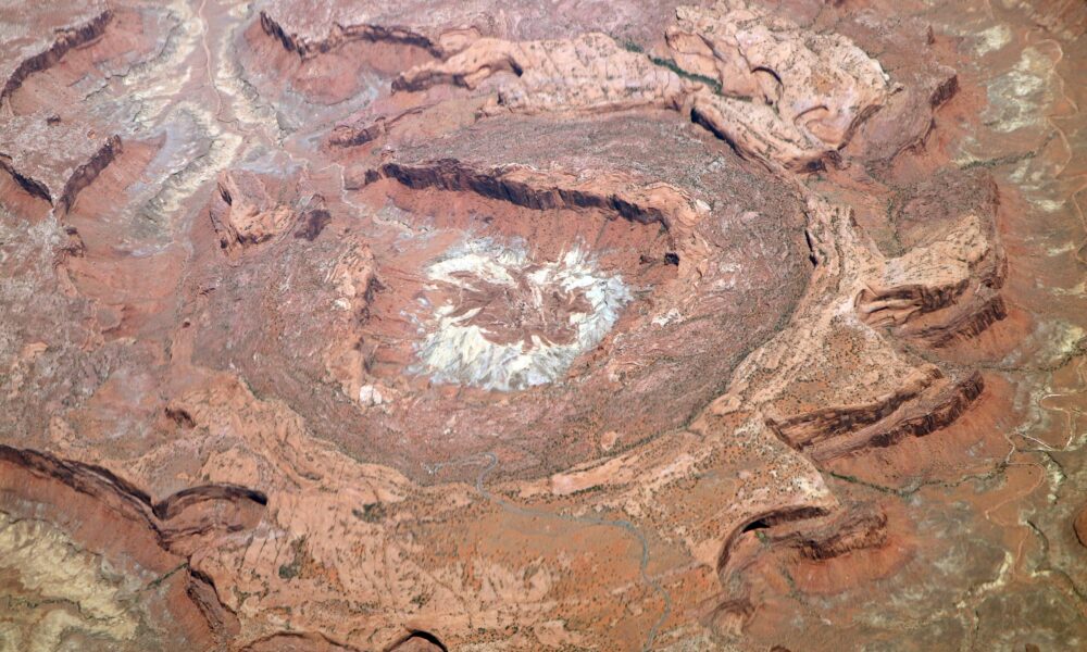

Upheaval Dome, Canyonlands National Park
Based on that picture, it’s pretty clear why they call it Utah’s “belly button.” But behind that cute nickname is an ancient crater that geologists have debated for decades. Scroll right to see what led them to its origin story, and why it’s one of the best trails you can hike at Canyonlands National Park.

A Giant Bowl in the Desert
Don’t like the belly button thing? Think of a giant bowl carved into the desert, about three miles across and over 1,000 feet high. You’ll find this odd formation in Canyonlands National Park’s Island in the Sky district.
The structure has twisted rock layers forming rings, with the center pushed up like a dome. These rocks look completely different from the flat sandstone and shale layers in the rest of the Colorado Plateau, making it stand out in the desert landscape.

Scientists Argued About Its Origin for Decades
Scientists argued for years about how this formation came to be. Some thought it formed from a salt dome pushing up from below, similar to a bubble rising in thick syrup. Others believed a meteorite crashed into Earth, creating a massive crater. The debate went on for decades with both sides showing strong evidence for their ideas.

Shocked Quartz Proved It Was a Meteorite Crater
In March 2008, confirmation from German scientists stated that Upheaval Dome was caused by an impact when shocked quartz grains were found in the Jurassic Kayenta Formation.
Electron microscopy revealed that these features were high-density dislocations with fluid inclusions, confirming the high-pressure impact origin.
The presence of planar deformation features in the quartz grains provides definitive proof of the impact, as such lamellae can only form under extreme pressures of over 10,000 atmospheres, which occur during an impact event.
The findings suggest the impactor created shock pressures of about 10 GPa within 1.3 km of the crater center.
In other words: This special quartz only forms under extreme pressure, like during a meteorite strike.

Nobody Knows When the Impact Happened
We know how Upheaval Dome formed but not exactly when. Scientists can only say it’s younger than 170 million years old, based on the Navajo Sandstone layer it broke through.
Some think it happened during the Jurassic Period, about 140 million years ago. Others suggest it might be more recent, perhaps 60 million years ago. Without fossils or materials that can be directly dated, the exact age remains unknown.

Astronauts Photograph It from Space
From the ground, you can’t fully see how big Upheaval Dome is. In satellite images, it appears as a clear circular feature against the surrounding landscape. Astronauts on the International Space Station have taken photos of it multiple times.
From above, the alternating rock layers of Upheaval Dome form a nearly circular ‘bull’s-eye,’ about 5.5 kilometers (3.4 miles) in diameter. The oldest rocks, including the Chinle and Moenkopi Formations, are in the center, surrounded by progressively younger layers like the Wingate Sandstone, Kayenta Formation, and Navajo Sandstone.

Most of the Original Crater Has Eroded Away
What you see today is just a shadow of the original crater. Roughly a mile of rock has worn away since the impact. The original crater was much deeper with a central peak like fresh impact craters elsewhere.
Wind, water, and ice have slowly eroded the upper portions over millions of years. This gives scientists a rare chance to study the deep structure of an impact crater that’s usually hidden from view.

Upheaval Dome Has Fantastic Hiking Trails
For a nice challenge, try the Syncline Loop Trail that circles the entire crater. This 8.5-mile trail offers amazing views from all angles as you walk around the formation. The Syncline Loop is a strenuous hike with a total ascent of 2,050 feet.
It starts at an elevation of 5,650 feet and reaches a highest point of 5,750 feet, while the lowest elevation is 4,175 feet at around 3.25 miles when hiking clockwise.

Other Natural Wonders Nearby
Upheaval Dome sits among many other natural wonders in Canyonlands National Park. Mesa Arch is just a short drive away, where sunrise turns the stone a glowing orange-red. Grand View Point shows off views stretching over 100 miles on clear days.
Nearby Dead Horse Point State Park features a stunning overlook of the area with an elevation of 5,900 feet above sea level.

Getting to Upheaval Dome
Upheaval Dome sits in the Island in the Sky district of Canyonlands National Park, about 22 miles southwest from the city of Moab, Utah.
The park stays open year-round, but spring and fall have the best hiking weather. A short 1.5-mile round-trip takes you to the first overlook, while a 2-mile round-trip reaches the second viewpoint.
The park charges about $30 per vehicle for a 7-day pass. You’ll find restrooms at the trailhead but no water, so bring plenty. Summer temperatures often top 100°F, so plan for early morning visits in hot months.
The post This is Utah’s “Belly Button” – An Ancient Asteroid Impact Site with Awesome Hiking Trails appeared first on When In Your State.