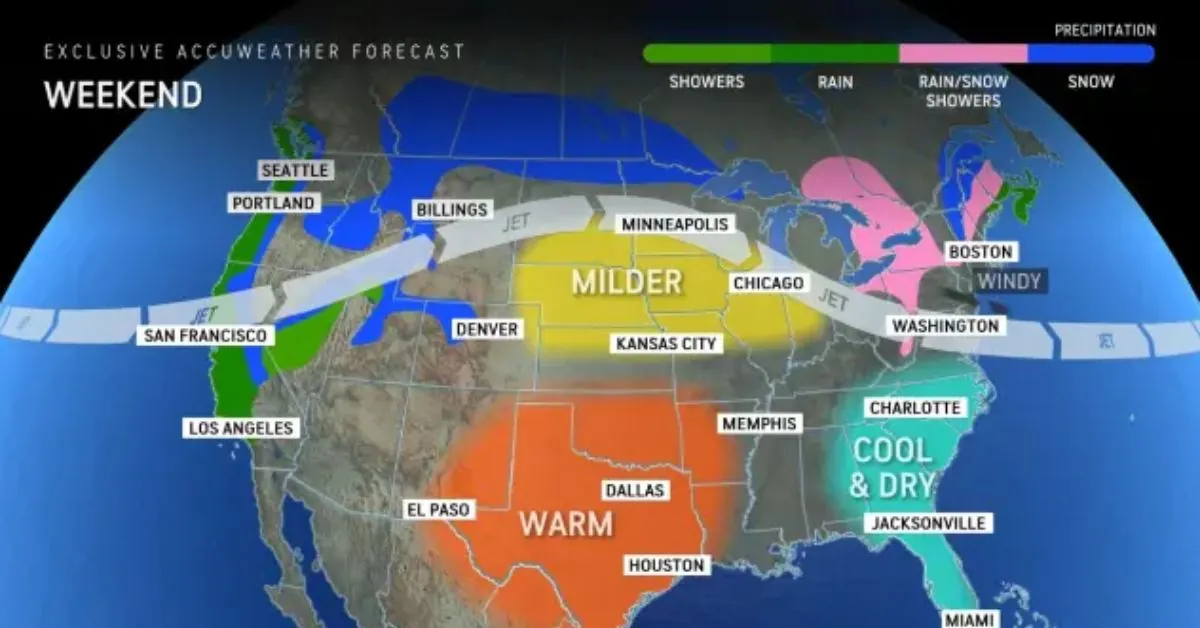
AccuWeather forecasters predict that the storm-weary West will continue to face travel disruptions from rain, wind, and snow. We expect another round of busy weather, this time extending as far south as Los Angeles, to hit the region late this weekend and early next week ahead of the Thanksgiving holiday.
Over the previous week, the continuous pattern in the Northwest and Northern California has generated rounds of heavy rainfall, mountain snow, and fierce coastal winds.
Earlier this week, power outages in Washington alone reached at least 600,000 customers when a bomb cyclone brought severe winds across the region. A bomb cyclone is a storm that intensifies rapidly, causing the central air pressure to drop by 0.71 of an inch (24 millibars) or more within a 24-hour period, often resulting in devastating winds as the storm intensifies.
According to PowerOutage.us, at least 185,000 consumers in Washington remained without power as of Friday. Nearly 12,000 customers were without power on Friday morning in northwestern California, where coastal gusts gusted up to 50-60 mph Thursday night.
The next storm is on the horizon
As one storm fades and shifts inland, there may be a brief break in the wet trend at the start of the weekend for parts of coastal Northern California. This respite will be short-lived as another wave of moisture arrives between late Saturday night and Sunday.
Later this weekend, the next set of storms will hit the California coast again, eventually moving inland and dumping snow in Nevada, Utah, and parts of Colorado until the beginning of next week.
Forecasters anticipate a notable shift in this upcoming cycle, not just in the region along the West Coast.
Over the weekend, we expect the Sierra Nevada’s snow levels to drop to roughly 4,500–5,500 feet, causing widespread snowfall across the region’s well-traveled mountain passes. By Monday, snow levels could reach 5,000–6,000 feet across the range.
As rain moves southward throughout California early next week, showers will spread to the Central Coast and even Los Angeles.
“Currently, it looks like Monday night through Tuesday would be the best opportunity for rain in Los Angeles,” Houk informed me.
Early next week, rain totals as far south as Ventura and Los Angeles counties in California will be low, but any rain that reaches the Los Angeles International Airport would be welcome, as the site last recorded measurable precipitation on November 2.
Rainfall totals will be slightly higher further north across the state, but not on the scale of previous bouts of rain seen over the last week.
“One system Sunday into Sunday night across Northern California can bring 1-2 inches of rain, which can slow clean-up efforts and keep creeks, streams and rivers running high,” explained Houk.


![Tyson Foods Plant [Photo: Food Manufacturing]](https://southarkansassun.com/wp-content/uploads/2023/08/iStock_1185520857__1_.5e441daa51cca-600x337.jpg)




![Silverado Senior Living Management Inc. [Photo: Los Angeles Times]](https://southarkansassun.com/wp-content/uploads/2023/10/download-6-4-600x337.jpg)

![China's Wuhan Institute of Virology [Photo: Nature]](https://southarkansassun.com/wp-content/uploads/2023/09/d41586-021-01529-3_19239608-600x337.jpg)


